GOES R satellites revolutionize storm tracking and safety
This article was created by AI summarizing key points discussed. AI makes mistakes, so for full details and context, please refer to the video of the full meeting. Please report any errors so we can fix them. Report an error »
In a recent government meeting, officials highlighted the advancements in weather monitoring and forecasting technology, particularly focusing on the capabilities of the GOES R series satellites. These satellites have revolutionized the way meteorologists track severe weather events, providing critical data that can lead to timely warnings for the public.
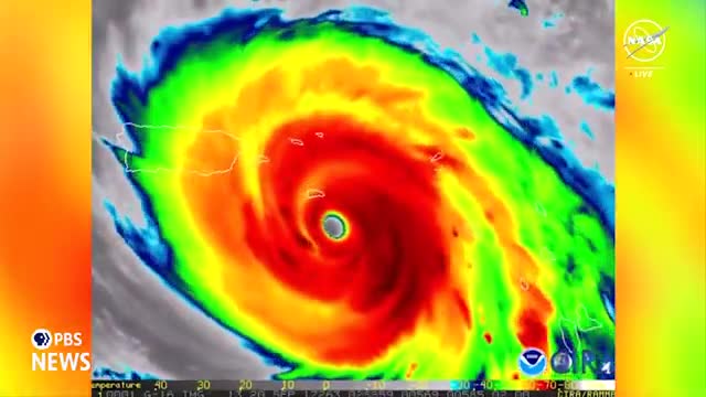
One of the key features discussed was the ability to scan large storms every 30 seconds, which allows for minute-to-minute updates on severe weather conditions. This capability proved essential during Hurricane Maria, which caused significant damage in Puerto Rico and knocked out local radar systems. Forecasters relied on satellite imagery to issue flash flood warnings and severe storm alerts in the absence of radar data.
The introduction of the Geostationary Lightning Mapper (GLM) has further enhanced forecasting accuracy. This tool allows meteorologists to observe lightning activity within storm systems, aiding in the assessment of storm intensity and potential development. Research is ongoing to better understand the implications of lightning presence in hurricane eye walls.
The meeting also addressed the application of satellite data in monitoring severe storms across the continental U.S., particularly in Tornado Alley. The ability to visualize lightning from supercells enables forecasters to predict the formation of thunderstorms and issue warnings accordingly.
A notable innovation discussed was the \"lightning cast,\" a machine learning algorithm developed by the University of Wisconsin. This tool predicts the likelihood of lightning strikes within the next hour, which can be crucial for outdoor events, allowing for timely safety measures.
Additionally, the satellites play a vital role in monitoring volcanic eruptions and detecting wildfires. The GOES R series has demonstrated impressive capabilities in identifying fire hotspots and tracking smoke, which poses risks to air quality and firefighter safety.
Looking ahead, plans for the Geostationary Extended Observations (GEOXO) program were announced, with the first satellite set to launch in 2032. This new initiative aims to enhance fire detection capabilities, allowing for earlier identification of smaller hotspots, thereby improving response times for emergency management.
Ken Graham, director of the National Weather Service, emphasized the transformative impact of the GOES R series since its launch in 2016, stating that it has significantly improved forecasting and warning services, ultimately helping to save lives and protect property. The continuous advancements in satellite technology are expected to further enhance the nation's ability to respond to severe weather events effectively.
View full meeting
This article is based on a recent meeting—watch the full video and explore the complete transcript for deeper insights into the discussion.
View full meeting