Greenville City advances North Main connector feasibility study to link neighborhood with Swamp Rabbit Trail
Loading...
Summary
City staff and consultants presented a feasibility update on a proposed North Main connector to the Swamp Rabbit Trail, shared four corridor design options, reported community engagement results, and said a preferred routing is emerging ahead of further engineering and a public open house.
Caitlin Owens, of the Greenville City project management office, and Jean Crowder, principal at Alta Planning, presented a feasibility update on a proposed North Main connector to the Swamp Rabbit Trail at a Greenville City work session. The consultants outlined route alternatives for three corridor segments, summarized community input and technical scoring, and said they expect a follow-up public meeting before the end of the year.
"The purpose of this is to connect the North Main community with the Swamp Rabbit Trail," Jean Crowder said, noting the neighborhood serves "over 5,000 residents" who need safe, convenient connections. Crowder said the project team remains in a feasibility phase and will shift to engineering once the city selects a preferred route and treatment.
Why it matters: the North Main neighborhood currently lacks an easy direct connection to the Swamp Rabbit Trail, and city staff and consultants said the connector would improve access to retail destinations and transit-oriented areas along Rutherford Road, Mohawk Drive and Wade Hampton Boulevard. The study couples community preferences with technical criteria to identify routes that are both buildable and cost-effective.
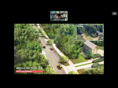
The consultants presented a short list of alternatives studied in depth and organized the corridor into three sections: north of Rutherford Road, a middle north–south connection (including North Main), and a southern gap to Wade Hampton Boulevard. For the northern section the team studied a Graves Drive option and a Renwick Drive option. For the middle section they evaluated routing along North Main Street (option 2a) and a Rutherford-to-Summit connection (option 2b). For North Main itself the consultants described four design treatments under consideration: a North Main Greenway, a two-way "Strollway," a neighborhood promenade in the median, and a side path on one side of the road. For the southern section the team compared a route using Gallivan Street and an alternative using Hillcrest/Parkwood connectors.
Consultants said community engagement reached roughly 816 participants through virtual and in-person events and surveys. "I was absolutely impressed, not just with the turnout, but the level of interest and thoughtfulness that community members had in this process," Crowder said. The engagement and the team's technical scoring generally aligned: the Gallivan Street connection and “North Main” treatments emerged as preferred corridors in the feasibility analysis. The presenters said alternatives labeled 3a and 4a (the Gallivan route and a southern connector) scored high on performance and low on anticipated per-mile cost.
Council members and other speakers raised neighborhood concerns that would affect final design: retaining or removing medians on North Main (residents value medians), the loss of on-street parking where a path is added, driveway crossings and visibility treatments (for example, colored crosswalks or other material changes), and the extent of right-of-way impacts on front yards and property maintenance responsibilities. One council member described a mix of "cautious optimism" and requests for more detail from residents about final appearance and maintenance. Crowder emphasized that driveway and crossing treatments, parking impacts and right-of-way encroachments are details that will be addressed in engineering and in further neighborhood outreach.
Next steps and schedule: presenters said they plan another public open house (consultants earlier said they were aiming for November–December; staff later confirmed a next public meeting "before the end of 2025") and will circulate a community survey targeted to residents whose properties are adjacent to proposed routes. After further public input and finalization of a preferred route, the project will move from feasibility into engineering and detailed design.
No formal votes were recorded on the connector during the session; the item was presented for discussion and direction.
Ending: City staff and consultants will return with refined routing and design concepts after the next round of public engagement and the project’s feasibility report is completed. Community members and property owners along the proposed corridors will be asked for targeted input in the upcoming survey and open house.