Get Full Government Meeting Transcripts, Videos, & Alerts Forever!
Pima County and Universities test GIS method to prioritize neighborhood-scale stormwater parks
Summary
Pima County Regional Flood Control District and university researchers presented a GIS-based, multi-criteria method to identify neighborhood-scale sites for green stormwater infrastructure to reduce flooding and provide community benefits.
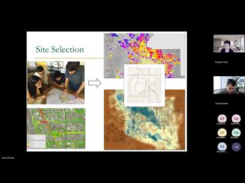
Pima County Regional Flood Control District on Tuesday presented a GIS-based, multi-criteria method to identify candidate sites for neighborhood-scale green stormwater infrastructure, aiming to reduce flood risk and provide co-benefits such as tree canopy and heat relief.
The presentation, delivered by Jacob Prieto, chief hydrologist for the Flood Control District, and researchers led by Dao Xingtong of Arizona State University, described results from year two of a three-year study that applied flow-2D simulations, floodplain layers and socioeconomic, environmental and parcel-level data to score and rank potential GSI locations in three Tucson study areas (labeled A, B and C).
Why it matters: Pima County is required to perform stormwater mitigation analyses to support its MS4 permit obligations. The district and university partners say a parcel- and neighborhood-level scoring tool could help prioritize investments in “stormwater parks” (roughly one-acre basins with small watershed areas) that both capture runoff and expand local green space in flood-prone, heat-vulnerable…
Already have an account? Log in
Subscribe to keep reading
Unlock the rest of this article — and every article on Citizen Portal.
- Unlimited articles
- AI-powered breakdowns of topics, speakers, decisions, and budgets
- Instant alerts when your location has a new meeting
- Follow topics and more locations
- 1,000 AI Insights / month, plus AI Chat