Nantucket working group advances curving "dune‑swoop" boardwalk design for Francis Street Beach
Loading...
Summary
The Washington Street collaborative work group voted unanimously Oct. 3 to advance the curvilinear “dune‑swoop” alternative into 30% schematic design for the Francis Street Beach boardwalk, while directing staff and consultants to test a ramp to the north and explore keeping the existing kayak/restroom facility in place.
The Washington Street collaborative work group voted unanimously Friday to advance the curvilinear “dune‑swoop” design for the Francis Street Beach boardwalk into the 30% schematic design phase.
The vote, made during the Oct. 3 meeting, instructs the project team to refine the dune‑swoop geometry, test whether a future northward ramp can be built to meet ADA requirements, and study whether the existing kayak rental shed and restroom — a long‑standing on‑site concession — can remain in its current location while meeting permitting and utility requirements. The motion was made by Alan (last name not specified) and seconded by John (last name not specified); all voting members present said “aye.”
The decision follows technical briefings from consultants on coastal performance, grading and permitting. Kirk of the Woods Hole Group summarized recent coastal modeling, saying the two main concepts perform similarly: "the overall performance of the sand movement isn't gonna be, that different between either of the two cases." That finding helped frame the choice as largely one of geometry, cost and site operations rather than coastal resiliency.
Why it matters: The selected dune‑swoop approach aims to create a dune crest high enough to reduce near‑term storm impacts while keeping beach access and visual openness. Consultants said the design choices will affect permitting, cost and how the boardwalk ties to adjacent properties and future shorefront connections.
What consultants presented Todd (PAR team), the engineering lead, described the move to a pile‑supported boardwalk to allow natural dune migration beneath the structure and explained several design constraints. "For building code requirements, we need to maintain at least less than 30 inches of a drop off from the boardwalk to the beach or to the dune. If you are at 30 inches or greater, we need a handrail," he said, noting the team’s current recommendation to grade at about 18 inches so small dune movement can be managed without adding handrails.
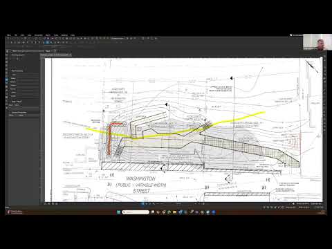
Woods Hole Group recommended dune slopes that are steeper on the landward face (up to about 3:1 toward Washington Street) and more gradual on the beach side (about 10:1), and a target dune crest elevation of about 8 feet, with the boardwalk reaching roughly elevation 9. The team also suggested modest beach nourishment to an elevation near 5 feet to improve beach usability and help grading for accessible routes.
Permitting and constraints Adrienne (permitting consultant) summarized expected regulatory filings and thresholds, listing federal, state and local requirements the team expects to pursue: "Army Corps of Engineers section 10/404 permit, the DEP 401 water quality certification, DEP waterways, an order of conditions through the Wetlands Protection Act," plus consultations with the Division of Marine Fisheries about shellfish habitat, Chapter 91 licensing and NEPA documentation for coastal work. She also noted the project area is in a velocity zone and that an expanded environmental modification form or a single environmental impact report is likely.
Site‑specific issues raised - Existing restroom/shed and kayak rental: The team discovered an existing shed with restroom plumbing and sewer connection within the project footprint. Project staff said they have already met with the concession operator (identified in prior outreach as Ryan Pitch) to discuss accommodating the rental use. Meeting participants emphasized the operational importance of kayak storage and access; the concession’s lease runs through 2027. - Adjacent property coordination: Consultants recommended coordination with the abutting northern property owner and a potential sheet‑pile extension or geotube to reduce scour where high‑velocity flows might concentrate between the dune and that property. - Landscape wall: A low landscape or retaining wall at the Washington Street right‑of‑way edge was proposed to limit sand overwash onto the street as the dune migrates. - Accessibility and pedestrian connections: The working group discussed multiple options for pedestrian access from Washington Street Extension where sidewalks stop. Designers proposed either a crosswalk/shared street treatment, a sidewalk on the opposite side of the street (which may require right‑of‑way adjustments), or an accessible ramp tied into the boardwalk. Lynn (grading lead) said a ramp from both sides might be feasible but challenging given existing grades: gaining elevation faster shortens run and affects geometry.
Design alternatives and cost considerations The team compared two refinements of earlier concepts: the more sinuous "dune‑swoop" and a more angular beach overlook. Consultants said the coastal performance is similar between the two, but curvature raises construction and framing complexity and therefore cost. Todd noted curved sections require more specialized framing and detailing; the angular option is easier to build. Still, several working group members preferred the dune‑swoop for aesthetics and for creating slightly more usable beach area.
Meeting outcome and next steps The group unanimously chose the dune‑swoop (curvilinear) alternative to advance into schematic design. Participants asked consultants to: - Test feasibility of a northward ramp that would provide an ADA‑accessible connection from the crosswalk area to the boardwalk; - Evaluate options to keep the existing kayak/restroom shed in place, including utility and lease constraints, and to locate required kayak storage; and - Refine grading to meet the dune target elevation (approx. 8 feet), boardwalk elevation (approx. 9 feet), and beach elevation target (approx. 5 feet) while minimizing permit impacts.
The consultants will also continue permit planning (Army Corps, DEP, Wetlands Protection Act/Conservation Commission, Division of Marine Fisheries, Chapter 91 and NEPA coordination) and produce materials for the next working group check‑in. The team is targeting delivery of schematic design technical documents and a cost analysis before year‑end, with operations and maintenance guidance to follow in the new year. The next working group meeting is scheduled for Oct. 24.
","sections":{"lede":"The Washington Street collaborative work group voted unanimously Friday to advance the curvilinear “dune‑swoop” design for the Francis Street Beach boardwalk into the 30% schematic design phase.","nut_graf":"The vote directs consultants to refine the dune‑swoop geometry, test a northward ADA ramp, and study whether the existing kayak rental shed and restroom can remain in place while the team proceeds through federal, state and local permitting. The choice follows coastal modeling showing similar performance between alternatives and shifts the decision toward geometry, cost and operational fit.","ending":"Consultants will return with refined sketches and technical memos on grading, ramp feasibility, the kayak/restroom location, and permit strategy; schematic design materials and a cost estimate are due before the end of the year, and the working group reconvenes Oct. 24."},