Get Full Government Meeting Transcripts, Videos, & Alerts Forever!
Consultants present Flow2D modeling, screening for managed recharge in Wilcox Basin
Summary
Consultants told the Cochise County Flood Control Board staff on Sept. 30 that a weeklong Flow2D hydrology and hydraulics model of the 1,700‑square‑mile Wilcox Basin plus a GIS screening identified priority areas for managed aquifer recharge near major drainages such as Turkey Creek and Ash Creek.
Consultants for Cochise County presented a county-funded hydrology and recharge screening study that used Flow2D modeling and a GIS suitability analysis to target sites for managed aquifer recharge in the Wilcox Basin. The presentations were given during a Flood Control District work session Tuesday in the Board of Supervisors chamber in Bisbee.
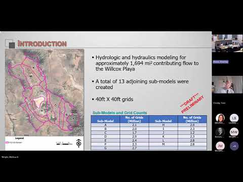
The consultants said the modeling covered about 1,700 square miles and used a cascading approach of 13 linked submodels. "We broke that 1,700 square miles into 13 individual models that run on their own, and we broke the whole 1,700 square mile area into 40 by 40 foot grids," said Sai Miller, an engineer with JE Fuller, describing the spatial resolution used for flood‑flow and depth outputs. The project is funded, the county said, by a WIPA grant for $187,000 and Flood Control District funds of $112,000.
County and consultant speakers said the Flow2D runs simulated a 100‑year, 24‑hour type‑2 storm and produced depth and velocity rasters and flood hydrographs for each 40‑by‑40‑foot cell. Miller noted that the model is computationally intensive — a full run of the cascaded models took…
Already have an account? Log in
Subscribe to keep reading
Unlock the rest of this article — and every article on Citizen Portal.
- Unlimited articles
- AI-powered breakdowns of topics, speakers, decisions, and budgets
- Instant alerts when your location has a new meeting
- Follow topics and more locations
- 1,000 AI Insights / month, plus AI Chat