Get Full Government Meeting Transcripts, Videos, & Alerts Forever!
Get email alerts on the Water Supply Managed Recharge topic
No spam. Unsubscribe anytime.
Consultants present Flow2D modeling, screening for managed recharge in Wilcox Basin
Summary
Consultants told the Cochise County Flood Control Board staff on Sept. 30 that a weeklong Flow2D hydrology and hydraulics model of the 1,700‑square‑mile Wilcox Basin plus a GIS screening identified priority areas for managed aquifer recharge near major drainages such as Turkey Creek and Ash Creek.
Consultants for Cochise County presented a county-funded hydrology and recharge screening study that used Flow2D modeling and a GIS suitability analysis to target sites for managed aquifer recharge in the Wilcox Basin. The presentations were given during a Flood Control District work session Tuesday in the Board of Supervisors chamber in Bisbee.
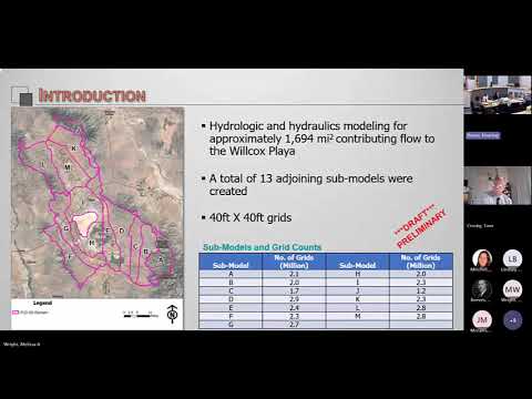
The consultants said the modeling covered about 1,700 square miles and used a cascading approach of 13 linked submodels. "We broke that 1,700 square miles into 13 individual models that run on their own, and we broke the whole 1,700 square mile area into 40 by 40 foot grids," said Sai Miller, an engineer with JE Fuller, describing the spatial resolution used for flood‑flow and depth outputs. The project is funded, the county said, by a WIPA grant for $187,000 and Flood Control District funds of $112,000.
County and consultant speakers said the Flow2D runs simulated a 100‑year, 24‑hour type‑2 storm and produced depth and velocity rasters and flood hydrographs for each 40‑by‑40‑foot cell. Miller noted that the model is computationally intensive — a full run of the cascaded models took about a week — and that verification compared model outputs to USGS regression results (the basis for StreamStats) because the basin lacks long‑term rain and stream gauges for classical calibration. "We did 51 basins," Miller said when describing the scope of modeled drainage areas.
The model outputs were integrated with a GIS suitability screening by Geosystems Analysis to identify parcels favorable for recharge. "Our goal at GSA specifically was to identify areas suitable for recharge," said Lindsay Bunting of Geosystems Analysis. The screening combined near‑surface permeability from NRCS soils, modeled flood depths from the Flow2D outputs, ADWR groundwater‑model drawdown (1940–2015), land use, and other factors. Parcels were scored on 40‑ to 160‑acre sampling units; 18 sections (township sections) received the top score in the preliminary screen, and the highest ranked areas clustered along major drainages including Turkey Creek and Ash Creek.
Consultants described how the screening would be followed by more detailed site vetting. Bunting said the next phase would assess deeper vadose‑zone properties with well logs, field tests (for example test pits, boreholes or geophysics), groundwater‑quality checks and landowner and agency engagement before any design or construction. "There are still future phases. This is all a screening study based on geospatial data. We still need to do a field investigation to confirm the suitability," Bunting said.
County staff and consultants noted limits and technical choices in the work. Miller said Flow2D represents topography as a gridded mesh with flow allowed in eight directions; he said the team selected a type‑2 temporal rainfall distribution after comparing type‑1, type‑2 and ADOT frequency distributions and deciding type‑2 matched their verification targets better. The team also used the Green‑Ampt method for infiltration and Manning’s n for channel roughness. County staff noted the model relied on the county’s high‑accuracy LiDAR topography (USGS acquisition) and on national NOAA precipitation frequency data for design storms.
Next steps listed by staff include follow‑up field evaluations at prioritized parcels (the team described a target of examining several candidate sites), landowner and NRCD/NRCS coordination to pursue projects such as gabions and check dams where appropriate, and additional model queries to deliver more detailed site‑level hydraulic outputs for design. The consultants and staff cautioned that final site selection would require checking for deeper low‑permeability layers, groundwater quality constraints and permitting with ADWR or other state agencies.
If implemented, consultants said, targeted recharge features could be smaller in‑channel structures (gabions, check dams), spreading basins, flood‑marriage to agricultural land, or engineered bypass/infiltration features (dry wells or trenches) depending on local subsurface conditions. Bunting said siting recharge near large drainages minimizes conveyance cost and maximizes available floodwater for recharge. "We need to be in close proximity to high capacity drainages," she said.
County staff and consultants did not propose or approve specific construction actions at the work session; they described a multi‑phase technical and outreach pathway that the county will use to move from modeling to site‑level investigation and, if warranted, to project design.