Get Full Government Meeting Transcripts, Videos, & Alerts Forever!
Get email alerts on the Right Of Way Vacation topic
No spam. Unsubscribe anytime.
Planning commission backs vacation of South Fairview right-of-way, sends amended exhibit to council
Summary
The Woodland Park Planning Commission voted unanimously to recommend that city council approve a vacation of a 60-foot undeveloped section of South Fairview Street, subject to corrected legal descriptions and a staff/legal review of which code provision controls how the vacated land would be divided among adjacent owners.
Woodland Park Planning Commission members voted unanimously Thursday to recommend that city council approve a request from Andre Brewington to vacate a 60-foot-wide, undeveloped portion of South Fairview Street north of Foster Avenue and south of Woodland Avenue, sending the item to council with conditions requiring a corrected legal exhibit and a staff/legal determination of which municipal-code provision governs division of the vacated land.
The request, which concerns a small triangular remnant of land at the southwest corner of Block 16 in the Foster’s Addition to Manitou Park plat, drew an extended staff presentation and public testimony. “Staff's recommendation is for planning commission to recommend city council deny the request to vacate a portion of South Fairview Street,” Senior Planner CJ Gates said during the presentation, citing utility access, parcel configuration and neighborhood character as concerns. Despite that recommendation, commissioners voted to forward the application with conditions so city council can decide.
The triangle of land in dispute sits west of Woodland Avenue and east of Foster Avenue. City staff said a recent survey provided by the applicant shows the applicant's parcel is roughly 2,862 square feet, substantially smaller than the city’s UR (urban residential) district minimum lot size of 7,500 square feet. The county assessor’s abbreviated description lists a larger figure (about 0.12 acres or 5,227 square feet). Gates said that if the right-of-way were vacated and divided down the middle as required by the code, the applicant’s parcel would increase to roughly 8,064 square feet; with setbacks and steep slopes, staff calculated a potential buildable envelope of about 1,382 square feet.
Gates explained infrastructure constraints: Woodland Park Utilities told staff it does not have water planned to serve this leftover parcel and that water service would require the applicant to extend mains. Gates said the utilities department “does not approve of the right-of-way vacation because there is no physical water available to serve this lot unless the applicant extends the water main.” If the vacation is approved, Gates said the city would reserve a 10-foot-wide general utility easement centered on the vacated right-of-way.
Applicant Andre Brewington told commissioners he bought the parcel in December and that he intends to replat the land if the vacation and subsequent subdivision processes allow. “I am a disabled veteran looking to build a home for my family,” Brewington said. He told the commission he has discussed buying additional adjacent strips from neighboring owners to increase the buildable footprint and that he is prepared to pay to extend utilities; he estimated extension costs “in excess of $60,000.”
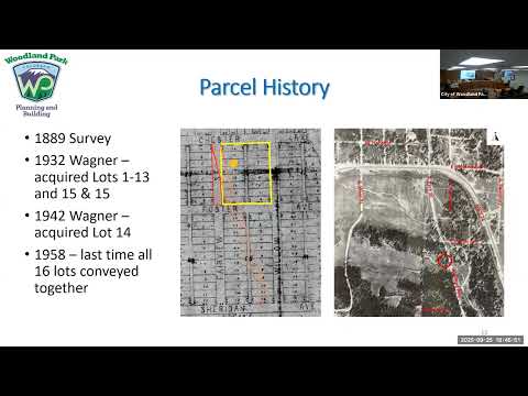
Commission discussion focused largely on three technical issues: (1) the tangled chain of historical conveyances producing an unusually shaped “scrap” parcel, (2) whether the vacated right-of-way should be divided under municipal-code provision 12.08.020(c) (an equal centerline split) or (d) (each abutting owner takes the portion nearest their land), and (3) whether parks and recreation should be asked to review the parcel as potential public open space or trail connection. Several commissioners asked staff to obtain the parks-and-recreation board's view before council action.
After more than an hour of testimony and questions, a commissioner moved to recommend approval to city council; another commissioner seconded the motion. The planning commission’s motion included three conditions: require the applicant provide a corrected legal-description exhibit for the ordinance recordation, require staff/legal review to determine whether code subsection (c) or (d) of municipal code 12.08.020 applies to the northern portion, and require that the final map showing how the vacated right-of-way would be divided be available to council. Commissioner Jared Newcomb seconded the motion.
The roll-call recommendation to council carried unanimously. Commissioners recorded their votes by name: DeSellum — yes; Hartsfield — yes; Hoying — yes; Kennedy — yes; Newcomb — yes; Brown — yes; Larson — yes.
The commission’s recommendation does not grant any future permits or guarantees utility taps; commissioners and staff emphasized that any building permit, subdivision or water-tap request would require separate approvals and that council will make the ultimate decision. Planning staff said the item is currently scheduled for a city council public hearing on November 6.
The commission’s files, the applicant’s survey and the corrected exhibit will be part of the record the council reviews. The commission’s discussion also flagged the parcel’s topography, recorded deed language and assessor disclaimers as points council may consider when weighing whether vacating the right-of-way serves the city’s interest in public access, utilities and neighborhood character.