Get Full Government Meeting Transcripts, Videos, & Alerts Forever!
Buckeye unveils airport master plan, outlines long-range runway and land-use vision
Summary
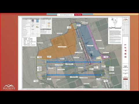
City of Buckeye aviation staff and consultants presented a draft Airport Master Plan and an associated long-range airport development vision at the Sept. 16 council workshop, outlining infrastructure needs, phasing and estimated costs for the next 20 years and beyond.
City of Buckeye aviation staff and consultants presented a draft Airport Master Plan and an associated long-range airport development vision at the Sept. 16 council workshop, outlining infrastructure needs, phasing and estimated costs for the next 20 years and beyond.
Scott Craig, Aviation Director for the City of Buckeye, described the Airport Master Plan as "a federal aviation required planning document" that sets a 20-year capital plan and supports eligibility for FAA and state funding. Craig and consultant Charlie McDermott (Dibble) walked the council through recommended airside and landside projects, a long-range development concept and next steps for adoption and FAA concurrence.
Why it matters: The plan maps out potential runway extensions, a new crosswind runway, taxiway and apron improvements, expanded hangar capacity and non-aviation development areas tied to regional economic growth. Staff emphasized the plan is intended to preserve options and to make Buckeye more competitive for aviation users, cargo and potentially commercial service in the long term.
Already have an account? Log in
Subscribe to keep reading
Unlock the rest of this article — and every article on Citizen Portal.
- Unlimited articles
- AI-powered breakdowns of topics, speakers, decisions, and budgets
- Instant alerts when your location has a new meeting
- Follow topics and more locations
- 1,000 AI Insights / month, plus AI Chat