Get Full Government Meeting Transcripts, Videos, & Alerts Forever!
Get email alerts on the Neighborhood Character topic
No spam. Unsubscribe anytime.
Clayton staff begins citywide inventory to define neighborhood architectural character
Summary
City planning staff started an in‑house inventory of every residential property to identify prevailing neighborhood character and check whether existing zoning and architectural guidelines align with that character.
Clayton planning staff on Aug. 12 described a citywide effort to catalog residential building form, materials and site features to determine whether each neighborhood has a prevailing “character” and whether existing zoning and design rules match those patterns. Director of Planning Anna Crane told the Board the project grows out of the city’s comprehensive plan and is intended to guide any future design guidance without creating historic‑district regulations.
The work will catalog building massing, rooflines, materials, garage location, driveways, setbacks and density, staff said. “The outcome of the work…is not going to be a historic district. It’s not going to be a detailed preservation ordinance,” Crane said, adding that the first phase is an in‑house, higher‑level analysis rather than a specialist preservation study.
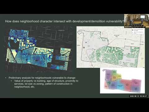
Planner Ryan Helley described the data approach and a GIS tool staff are using to tag and visualize property features. “A darker blue…means a property with high land value but low building value — potentially vulnerable to demolition and redevelopment,” Helley said while showing an early “vulnerability” layer. Staff said they will combine remote sources such as Google Street View with in‑person field verification and already‑available datasets (lot coverage, floor area ratio) to produce heat maps showing concentrations of materials and styles.
Early, limited reviews focused on the Moreland and Skinker Heights areas. Helley said those reviews show properties “don’t fit into a neat box” but can have neighborhood‑scale relationships driven by materials, setbacks and finished‑floor heights. Staff has created nine reference style categories to reduce individual rater variation; each reviewer will inventory whole neighborhoods so internal consistency is preserved, Crane said.
Crane stressed the project’s sequencing: staff will first seek to identify and quantify patterns, then compare those patterns to existing architectural guidelines, zoning and the comprehensive plan goals, and only after that consider whether new regulations, design districts, or other tools are required. She also emphasized flexibility: the effort aims to allow property owners reasonable design choices while protecting identified neighborhood patterns.
The board asked whether the work aims to stop neighborhoods from changing; Crane said that determination is a later step: “First, let’s figure out what the patterns are…then we can decide what implementation looks like.” Staff estimated the work will span into the next year and said collected data will be imported into existing datasets so it can inform multiple city projects.
Next steps: continued field verification, GIS analysis to map concentrations of materials and styles, and later comparisons of observed patterns with regulations to identify potential conflicts.