Get Full Government Meeting Transcripts, Videos, & Alerts Forever!
Get email alerts on the Highway Corridor Overlay topic
No spam. Unsubscribe anytime.
Planners refer Highway Corridor Overlay District for public hearing after design clarifications
Summary
The Planning Commission agreed to advertise a proposed Highway Corridor Overlay District for US Route 60 for a June public hearing after staff and VDOT clarifications and tweaks to buffer and entrance standards.
The Powhatan Planning Commission voted to refer a proposed Highway Corridor Overlay District (HCOD) for US Route 60 to a public hearing, with commissioners asking staff to clarify buffer tables, reference the VDOT road design manual year and tighten several language points before the hearing.
Planner Sean Clendening described the overlay’s goals as to “promote safe and efficient use of US Route 60, improve visual quality of corridor facing development, encourage coordinated site access and preserve natural and scenic features.” He told the commission the HCOD would apply to new commercial and industrial development, redevelopment or exterior modifications requiring a site plan or building permit along roughly 12 miles of US 60 from Maidens Road (Route 522) to the Chesterfield County line.
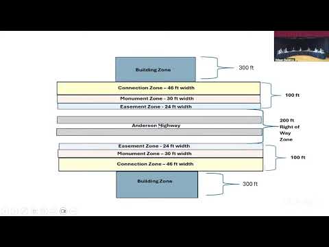
Key design items discussed included an increase to the front building setback from 75 feet to 100 feet measured from the ultimate right‑of‑way centerline, a series of functional zones within the corridor (right‑of‑way and monument, connection and building zones), a required 30‑foot “monument zone” buffer for signs and sidewalks, and a requirement that signage be monument style only (no pylon/pole or mass‑mounted pole signs). Clendening also summarized design rules: require shared entrances and interparcel connectivity, one‑row parking in the connection zone with larger parking to the side or rear of buildings, underground utilities and a prohibition on chain‑link and wood fencing within the corridor.
Clendening said VDOT provided comments asking staff to define the “ultimate right‑of‑way” as a fixed width measured from the road centerline and to reference the year of the VDOT Road Design Manual being used. Commissioners also discussed a pattern‑book requirement for commercial and industrial design standards and asked staff to convert a variety of existing perimeter buffer standards into a single, clearer table for commercial and industrial cases.
Several commissioners raised operational concerns. One commissioner asked that landscaping not obscure monument signage so motorists can find businesses without slowing or stopping in traffic. Another commissioner asked that fuel‑station canopies and drive‑through canopies be allowed to extend into setback areas when necessary for operations; staff responded those issues are reviewed at site‑plan stage and that exceptions can be pursued through the administrative process.
After those clarifications and with planned edits (move the entrance‑design figure earlier in the text, specify the VDOT manual and year, and finalize the buffer table), the commission moved to refer the HCOD to a public hearing for June 3. The referral passed by roll call: Chairman Hall Aye; Commissioner Bolen Aye; Commissioner Winnell Aye; Commissioner Hughes Aye; Commissioner Hatcher Aye.
The referral sends the draft ordinance and pattern‑book direction to a public hearing; actual text changes may be further revised before or at the hearing.