Get Full Government Meeting Transcripts, Videos, & Alerts Forever!
Get email alerts on the Transportation Highway7 topic
No spam. Unsubscribe anytime.
Council reviews MnDOT Highway 7 corridor study alternatives, urges local concerns about access and emergency response
Summary
Minnetrista City Council reviewed Minnesota Department of Transportation alternatives for the Highway 7 corridor that include roundabouts, nontraditional intersections and access restrictions; council members asked MnDOT to preserve certain access points, evaluate emergency response implications and consider a multiuse trail.
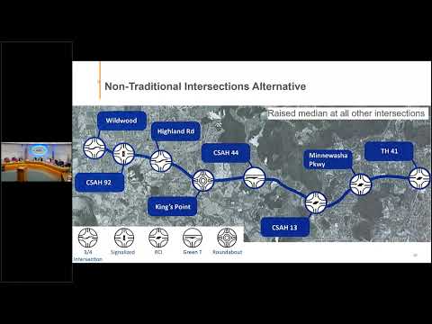
Minnetrista City Council on an agenda presentation reviewed a Highway 7 corridor study prepared by the Minnesota Department of Transportation that outlines three alternatives — a no-build option, a roundabout-focused alternative and a nontraditional-intersection alternative that includes reduced‑conflict intersections and three-quarter access points.
The council heard from presenter Lisonbee Felske, who said MnDOT “is looking to do some upgrades in 2029 with a resurfacing project between Wildwood Ave to approximately Mill Street,” and that the corridor study is intended as a guiding document to inform those and future projects rather than a final design.
Why it matters: Highway 7 is a principal arterial for Minnetrista and neighboring cities; MnDOT’s choices about access and intersection form will shape traffic flow, safety outcomes and where local traffic gets directed, with potential consequences for travel time and emergency response.
Council members raised several recurring concerns. Elected officials and staff asked MnDOT to preserve access at Hunters Trail (referred to in the materials as a three‑quarter access alternative rather than full access), to reconsider a two‑lane configuration at the Kings Point roundabout and to study emergency response implications where alternatives would reduce or reconfigure access near Marywood and other neighborhoods. Council members also cautioned that restricting access at Highland Road could divert Minnetrista traffic through Saint Bonnie, which they said could cause community impacts there.
Technical points discussed included traffic volumes and capacity. Staff said MnDOT reports current daily traffic in the segment at roughly 14,000 vehicle movements, with a near‑term projection closer to 20,000, and that MnDOT evaluates ADT (average daily traffic) and projected traffic when deciding whether multi‑lane roundabouts or other measures are needed. The presentation also noted that raised medians and longer merge lanes can reduce the severity of crashes and that medians typically taper roughly 200 feet before roundabouts to provide sight lines.
Council members and staff sought more detail on pedestrian crossings, trail connections and how student and emergency movements would be accommodated; presenters indicated MnDOT is proposing a trail (noted in the presentation as likely on the south side of Highway 7) and that pedestrian crossings at roundabouts raise design concerns. The council asked staff to press MnDOT for explicit emergency‑response analysis and to request MnDOT present to council again if the corridor concepts move into project design.
The presentation also reiterated that any actual construction proposals will follow municipal consent and public comment processes, and that the corridor study is intended to centralize background data so future development proposals can be evaluated against a corridor vision.
Council direction and next steps: City staff said they will forward council comments to MnDOT, will notify the council when MnDOT opens the formal public comment period, and will add links or notices to the city website so residents can review and comment. The presentation materials and MnDOT’s alternatives remain subject to change through design and public review.
Ending: Council members emphasized they were not approving any final design and asked staff to return material and any MnDOT responses about access preservation, emergency response times and trail design before any project advances to final design.