Get Full Government Meeting Transcripts, Videos, & Alerts Forever!
Get email alerts on the Vision 43 topic
No spam. Unsubscribe anytime.
West Linn planning commission narrows Vision 43 focus areas, signals support for housing and design rules along Highway 43
Summary
At an April 16 work session, planners and commissioners agreed to remove one focus area from the Vision 43 corridor study, signaled support for on-site housing and minimum building height, and discussed stepbacks and right‑of‑way constraints as staff prepares draft mixed‑use code for council.
At a work session Wednesday, April 16, the West Linn Planning Commission reviewed the Vision 43 Highway 43 corridor planning project and agreed to remove Focus Area 2 from consideration while giving staff direction on boundaries and three draft policy questions that will guide mixed‑use code drafting.
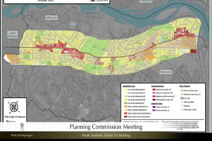
The discussion centered on a 3.3‑mile stretch of Highway 43 between the Lake Oswego–West Linn border and the I‑205 overpass. City planner Chris Myers told commissioners the purpose of the meeting was “to gather some feedback ... regarding 3 different things or 3 primary topics”: removing Focus Area 2, drawing the boundaries for Focus Areas 1–4, and answering three policy questions to forward to city council on May 2.
Myers said Vision 43 focuses on land uses adjacent to the highway — not highway pavement — and aims to create more walkable pathways, denser housing opportunities, and spaces for local businesses. “We are looking to create opportunities for more local businesses,” he said. He noted the project has generated extensive public engagement, asking commissioners to consider policy direction as consultants draft new mixed‑use code intended for adoption around December 2025.
Why it matters: decisions on Vision 43 will shape allowable uses, building scale and design along a key commercial corridor, and could influence future housing supply, pedestrian access and eligibility for Metro town‑center funding. Commissioners repeatedly emphasized balancing new development with neighborhood transitions and the practical limits of what the city can require without deterring private investment.
Key outcomes and staff directions
• Removal of Focus Area 2: Myers said the project working group recommended removing Focus Area 2 because recent changes in state law and allowed uses create a pathway for some institutional sites — for example churches — to pursue low‑income housing under current code. Commissioners gave a thumbs‑up consensus to remove Focus Area 2 from the study and move forward with three focus areas.
• Boundaries: Commissioners reviewed proposed boundaries for Focus Areas 1, 3 and 4. Focus Area 1 would include existing commercial properties near Walmart, 7‑11 and Burgerville and a portion of the Walling Circle parcels so that long, deep lots could be redeveloped as a coherent district over time. Commissioners asked staff to refine the line in a few places (Commissioner Evans requested three small parcels be considered for inclusion in Focus Area 3) and signaled general support for the boundaries as presented.
• Policy questions: Myers sought clear direction on three initial policy choices to inform draft code: - Should redevelopment within focus areas be required to include an on‑site housing component? Commissioners’ views varied but leaned toward supporting housing in the corridor as a tool to increase supply: “I’m a strong yes,” said Commissioner Evans. Commissioners also requested nuance and further study on location‑specific applicability and affordable‑housing mechanisms. Myers said the code will need objective, clear standards developers can follow and that subsequent meetings will refine where and how housing requirements would apply. - Should redevelopment have a minimum height of two stories? Commissioners generally favored a minimum of two stories to move away from single‑story strip‑mall development and to make better use of limited land, with discussion that three or more stories may be appropriate in parts of the corridor. - Should taller buildings adjacent to existing single‑family zones be required to step back as they rise? Commissioners expressed support for stepbacks as a way to soften transitions, preserve light, and avoid a canyon effect along the corridor. “For me this is very easy to support,” one commissioner said.
Other substantive points
• Right of way and jurisdictional transfer: Commissioner Evans asked whether the study contemplates redevelopment of the state right of way. Myers replied that “right of way would be under the control currently of ODOT” and that jurisdictional transfer is “being discussed,” but would be a major undertaking requiring tens of millions of dollars. He estimated a ballpark cost of “40 to $60,000,000” to bring the corridor up to local standards if the city were to take responsibility for the roadbed and associated infrastructure.
• Pedestrian and bicycle improvements: Myers and the consulting team (Kittleson and associates) described work to locate off‑highway walking and cycling links within one to three blocks of Highway 43. Myers said consultants have identified about 12 proposed new crosswalks the community has requested.
• Limits on big‑box retail and building size: Commissioners raised concerns about avoiding a patchwork of redevelopment or a single large owner building another big‑box store. Staff noted existing zoning carries limits: “There is a restriction on maximum size, which I think is 60,000 square feet in the zone currently,” and said the draft code will consider limits on structure size and first‑floor commercial standards to encourage local businesses.
Next steps
Myers said MIG and city planners are drafting the mixed‑use code and will return with additional policy questions and draft code segments in coming weeks. He will present the commission’s feedback to council at a May 2 work session and expects the formal adoption process to continue through late 2025. Commissioners and staff emphasized that property owners will be contacted once focus‑area boundaries are finalized; rezoning would allow different future uses but would not force immediate changes to existing homes or businesses.
Community context and caveats
Myers repeatedly noted Vision 43 addresses land use adjacent to the highway, not ODOT roadway maintenance or traffic striping. He stressed time frames are long: the project team told the commission the plan could take years to fully implement, and that earlier vision documents in neighboring cities took decades to reach full build‑out. The commission’s endorsements at the work session were informal direction for staff and consultants rather than formal votes.