Get Full Government Meeting Transcripts, Videos, & Alerts Forever!
Get email alerts on the Transportation Infrastructure topic
No spam. Unsubscribe anytime.
UDOT advances two free‑flow Western Corridor alternatives after traffic model update
Summary
Project team advanced two grade‑separated "free flow" Western Corridor alternatives (renamed Alternatives A and B) and eliminated at‑grade and US‑189 realignment options after rescreening prompted by a revised Mountainland travel model that raised 2050 traffic projections.
Heber Valley — Project staff for the Heber Valley Corridor Environmental Impact Statement (EIS) said they have advanced two grade‑separated "free flow" Western Corridor alternatives and eliminated previously studied at‑grade options and alternatives that would realign U.S. 189, after rescreening prompted by an updated regional travel demand model.
Naomi Keeson, environmental manager for the EIS, said the project’s purpose remains “to improve regional and local mobility on US 40 from SR 32 to US 189 and provide opportunities for non motorized transportation while allowing Heber City to meet their vision for the historic town center.” She told viewers the purpose, developed in 2021 and amended to add non‑motorized transportation, drives which alternatives are developed and screened.
The rescreening followed a late‑2023 update to the Mountainland Association of Governments (MAG) travel demand model, which included additional approved development east of North US 40 and in the Mayflower area. Craig Hancock, project manager for the Heber Valley Corridor EIS, said the new model projected “30% more traffic on North US 40 and 10% more traffic on Main Street in Downtown Heber City” compared with the earlier model; he said projected 2050 volumes on North US 40 could reach “nearly 50,000 vehicles per day.”
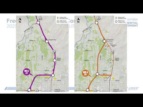
Those higher traffic forecasts led staff to drop the four at‑grade alternatives and carry forward two free‑flow variants of previously studied alternatives (previously labeled WB1 free flow and WB3 free flow). The two advanced options will be renamed for the draft EIS as Alternative A (WB1 free flow, which relies more on existing US 40) and Alternative B (WB3 free flow, which extends the Western Corridor farther north and uses a new alignment near Potter Lane).
Staff presented the screening rationale in three steps. A preliminary evaluation eliminated the four options that would realign US 189 because realignment showed no substantial regional travel‑time benefits, increased traffic on residential 1300 South (from about 7,000 to almost 19,000 vehicles per day for at‑grade cases), increased right‑of‑way and sewer‑farm impacts (nearly 16 additional acres for some free‑flow cases), and could require acquiring at least one residential property. Hancock said that combination of impacts and limited travel‑time benefit made those alternatives redundant with their counterparts that keep US 189 on its existing alignment.
Level 1 screening compared how well alternatives met the project purpose (regional and local mobility, non‑motorized accommodations, and compatibility with Heber City’s downtown vision). Keeson said all carried‑forward alternatives performed better than a no‑action baseline for Main Street operations, but the free‑flow options were “about 30 to 50% faster” regionally than their at‑grade counterparts and had far fewer conflict points — a key safety measure. For example, Keeson reported one conflict point on the free‑flow options versus up to 35 on some at‑grade designs.
Level 2 screening assessed impacts to key resources and costs. Hancock said Alternative A would have fewer impacts to waters of the U.S. (canals, ditches, streams and wetlands), while Alternative B would have fewer property impacts, including historic structures, but greater impacts to archaeological features such as historic canals, ditches and railroads. Neither free‑flow alternative was eliminated during level 2 screening; both will be carried forward for detailed analysis in the draft EIS.
Design details staff described include multi‑use trails, freeway‑style interchanges with limited access (interchanges or directional ramps only), frontage roads in some North US 40 segments, and higher design speeds on the Western Corridor. Hancock said the Western Corridor design speed would be 65 mph and US 40 would be 55 mph where both are used; cross‑section widths were cited at roughly 250 feet for the Western Corridor and about 230–325 feet for US 40 depending on location and interchanges.
Staff said the next steps are design refinements and a detailed impacts analysis across nearly 20 resource areas including transportation, water resources, cultural resources, noise, air quality, and ecosystems. Hancock said a preferred alternative will be identified and a draft EIS published “sometime this fall,” followed by public hearings and a comment period. Keeson emphasized that the public may review the full technical report and traffic analysis on the project website.
Questions and clarifications from the briefing emphasized tradeoffs among travel time, property and cultural impacts, and sewer farm impacts; staff described those tradeoffs as the basis for carrying two alternatives forward rather than selecting a single preferred option at this stage.