Get Full Government Meeting Transcripts, Videos, & Alerts Forever!
Get email alerts on the Industrial Land Readiness topic
No spam. Unsubscribe anytime.
Wilsonville planning commission reviews Basalt Creek industrial land readiness; developer urges single-zone approach
Summary
City staff presented Metro-required industrial protections, a market analysis showing low industrial vacancy, and draft land-use types for Basalt Creek. A Schnitzer Properties representative urged a single PDI zoning approach for a ~44–50‑acre Grama Ferry assemblage to avoid financing barriers from split zoning.
Wilsonville Planning Commission members met March 12 for a work session on the Basalt Creek Industrial Land Readiness Project, hearing staff presentations on Metro-directed regulatory limits and a market analysis, and public comment from a Schnitzer Properties representative about a large parcel assemblage in the area.
The briefing opened with staff explaining why parts of Basalt Creek inside Wilsonville were planned for industrial use and are subject to Metro’s employment-area protections. “My name is Cindy Luxoy, associate planner. And, we are here tonight … to seek planning commission's input on industrial land use types in Basalt Creek,” Cindy Luxoy said, summarizing the session’s purpose.
Why it matters: Metro added Basalt Creek to the region’s urban growth boundary in 2004 and applied Title 4 protections intended to keep the area available for employment (industrial) uses. Those protections restrict certain retail and customer‑facing commercial uses (for example, limits on single retail outlets and caps on total sales/service area) to preserve land for freight‑intensive and employment‑generating uses. The city’s economic development staff also told the commission that Wilsonville’s industrial market shows low vacancy and rising rents, indicating regional demand for development‑ready industrial parcels.
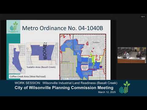
Staff and regulatory context Cindy Luxoy summarized the regulatory background: Metro Ordinance 4-10-40-B (adopted June 24, 2004) brought the Basalt Creek planning area into the urban growth boundary and tied the area’s future land uses to the regional growth concept and a planned freight connector. Luxoy noted Metro’s Title 4 protections and the Title 11 planning work that shaped where industrial versus residential uses were expected to occur.
City staff described implementation details that affect what can be built in the plan area. Luxoy said Title 4 “provides benefits of clustering to industries that operate more productively and efficiently when in proximity to each other.” She explained specific limits cited in the federal/Metro framework: single outlets with more than 5,000 square feet of sales/service area, or 20,000 square feet across a site, are constrained, and some large institutional uses (for example, schools or assembly places larger than 20,000 square feet) are prohibited in regionally significant industrial areas.
Market analysis and demand Matt Lorenzen, the city’s economic development manager, presented market data and said Wilsonville’s industrial market is tight. “In 2022, the city had over 21,000 covered employees,” Lorenzen said, and he later summarized vacancy and rent trends: Wilsonville’s industrial vacancy rate has generally remained low (the presentation cited a 2.6% vacancy rate in the city as of the most recent data), and rents have risen compared with some surrounding submarkets. Lorenzen told commissioners that much of regional industrial development has concentrated in Tualatin and Sherwood because those areas have development‑ready sites; by contrast, Wilsonville’s main constraint is a lack of development‑ready large parcels and associated infrastructure rather than a lack of land in total.
Commissioners probed those findings. Several commissioners pressed staff on the meaning of the low vacancy and the time frames used in the analysis; Lorenzen and other staff clarified that the vacancy comparisons reference Portland metro‑area data and that Wilsonville’s role must be read in that regional context.
Parcel size, infrastructure and market‑vs‑aspirational planning Staff said many industrial users and speculative developers prefer sites of 10 acres or larger; some developers seek 25‑acre or larger parcels. Lorenzen said much demand comes from existing regional businesses seeking to expand or modernize, not from large out‑of‑state headquarters moves. Commissioners and staff discussed the balance between “market‑driven” choices (what will likely develop given demand and finance) and “aspirational” planning (the city’s long‑term vision for higher‑quality, mixed employment uses). Several commissioners expressed support for aspirational planning while acknowledging the need to balance that with realistic infrastructure costs and market constraints.
Grama Ferry assemblage and public comment Staff identified an owner‑assembled group of parcels (the Grama Ferry assemblage) totaling roughly 44 acres in the plan area, with about 25 acres shown as light industrial and about 19 acres shown as high‑tech employment under the concept plan. A representative of Schnitzer Properties, who stated the company has owned the property for about two years, urged the commission to allow a single zoning district for the assemblage rather than split zoning along the concept‑plan colors.
The Schnitzer representative said the assembled site is large enough to attract speculative and institutional financing and argued split zoning would impede construction lending and delay infrastructure investment. “I can't go to a bank with a construction loan with a piece of property that is split zoned,” the Schnitzer representative said, warning that split zoning could leave large tracts fallow, slow infrastructure build‑out, and reduce near‑term tax revenue for the city and other local agencies. The Schnitzer representative described the firm’s model as a long‑term owner and builder of Class‑A, mixed industrial product that can include manufacturing, warehouse/distribution and higher‑quality “high‑tech” industrial tenants.
Transportation and constraints Staff described the transportation framework that underpinned the concept plan: the Basalt Creek Parkway, Day Road, and Grama Ferry/Boones Ferry corridors will be the primary arterials feeding the industrial area; portions of the parkway will be elevated and have limited driveway access, and Day Road will serve as the main access for many properties. Commissioners and staff also flagged a constraint for the West Railroad portion of the planning area: freight access there is limited by a railroad bridge/overpass, and resolving that constraint will require coordination beyond City of Wilsonville jurisdiction and be a longer‑term, complex infrastructure undertaking.
Next steps and commissioner direction Commissioners broadly supported the goal of preserving industrial land to meet regional responsibilities while debating the level of prescriptiveness for subdistricts (high‑tech, light industrial, craft industrial) and whether distinctions should be implemented as strict zoning limits or as incentives and design requirements. Staff said future work sessions will continue to refine land‑use definitions, subdistrict boundaries and implementation tools; they also offered to circulate the Basalt Creek transportation refinement plan for commissioners to review trip‑generation and roadway upgrade assumptions.
Formal actions The commission approved the February minutes as distributed during the meeting. No land‑use ordinances, annexations, zone changes or other final actions were taken at the March 12 work session.
Taper/what's next Staff will return to the commission with further detail on subdistrict boundaries, zoning approaches (prescriptive vs. incentive‑based), and transportation assumptions. Commission members requested additional follow‑up on (1) parcel aggregation strategies, (2) infrastructure costs and funding options, and (3) further analysis of the West Railroad access constraints.