Get Full Government Meeting Transcripts, Videos, & Alerts Forever!
Get email alerts on the Trails And Pedestrian Infrastructure topic
No spam. Unsubscribe anytime.
Milton trails committee adopts updated blueprint map, adds Taylor Road segment; staff to move plan to council
Summary
The Milton Trails Advisory Committee voted to adopt an updated citywide trails blueprint and approved adding a Taylor Road segment. Committee members heard survey results, discussed Deerfield-area branding and design options, and directed staff to prepare the map for council codification.
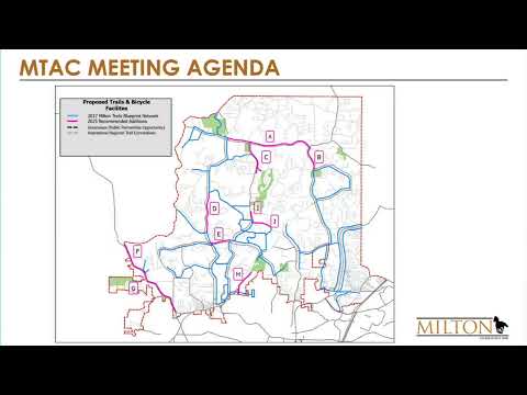
The Milton Trails Advisory Committee voted Thursday to adopt an updated trails blueprint map that adds several proposed connections across the city and approved a late amendment to include a Taylor Road segment from Batesville Road to State Route 372.
The committee’s action, taken by voice vote, follows a presentation of community survey results and a progress update on the Deerfield planning effort and a consultant branding study. City staff said they will prepare the adopted map for formal codification and placement on a future City Council agenda, likely this spring or early summer.
Why it matters: The blueprint is the committee’s prioritized, citywide guide for where sidewalks and multiuse trails should be built or sought through developer-built connections. Adopting the map is the step that allows staff to begin the formal council adoption and codification process and to submit the plan for funding and design work.
Committee discussion and public input summary
Suzanne Bach, a Trails Advisory Committee member, summarized recent meetings with council and the Deerfield plan consultant and urged committee members to think about branding, trail materials, trailheads and community outreach. “The first thing would be, like, to have a layer of public trails so we can see all…where we could put our mark on trails and then also for the public to kinda promote,” Bach said.
Staff presented the results of an online survey used to refine the blueprint. According to staff, New Providence and an east–west connection at the top of the city ranked highly among respondents. Segments on the west side of town (identified in the presentation as segments f and g) received the lowest positive response counts in the survey sample, staff said.
Committee members discussed surface materials, lighting and how to balance equestrian and bicycle uses. Staff noted survey responses favored concrete in denser areas like Crabapple/Deerfield and alternative surfaces in rural sections; 70% of respondents in the staff summary supported concrete for Crabapple/Deerfield while a majority said concrete or asphalt would not reduce their use of a trail. Staff warned that gravel drew more negative reactions from bicyclists and some other users.
On lighting and privacy, staff said expectations will vary by neighborhood and that lighting decisions will require balancing safety, homeowner concerns and preserving the night sky. Staff also summarized the city’s current legal framework for small personal vehicles: Milton’s city code and state law govern permitted use of golf carts (personal transportation vehicles), and additional council authorization would be needed to formally allow golf carts on specific trails.
Formal action and next steps
- Motion adopted: The committee approved the updated blueprint map (segments referenced a–j in staff materials) and directed staff to begin the council adoption process. The motion was made and seconded on the record; the map was approved by voice vote.
- Amendment adopted: Committee members then voted to add a segment on Taylor Road (west side) from Batesville Road to SR 372; that amendment was seconded and approved by voice vote.
Staff said it will provide committee members with the full PowerPoint and Excel survey data, deliver an existing-vs-proposed layered map for review, and work with the Deerfield project lead so committee input can be integrated without delaying the consultant’s schedule. Staff also said adopting the map will trigger the codification process and that committee members should expect to appear at council meetings when the item is scheduled.
Budget, funding and implementation considerations
Staff discussed funding sources and next-step opportunities including: (a) city appropriations already designated for some segments; (b) future TSPLOST or similar project lists (staff mentioned the possibility of large competitive project requests in the next funding cycle); and (c) competitive grants such as from the Path Foundation. Staff emphasized that many segments will require design, potential easement or property acquisition, and community outreach.
Committee context and engagement
Members emphasized community engagement and branding as ways to increase public support. The committee heard that consultants prepared a branding toolkit with logo, colors and sign concepts that the committee can use to develop consistent trailhead signs and promotional materials. Staff suggested selecting a marquee demonstration location (Birmingham Park and some gravel-road trailheads were discussed) to pilot signage and branding.
What the vote did not resolve
Staff and committee members noted outstanding questions that will require later work: precise alignment of several proposed segments (the side of the road or a route through an easement may change after engineering review), final decisions on surface types for each segment, lighting plans, maintenance responsibilities and specific funding allocations for any given segment. Staff said these details will be resolved during the design and council-adoption phases.
Committee membership and speakers quoted in this report
Trails Advisory Committee members and city staff participated in the discussion; committee appointments and staff roles were referenced repeatedly during the meeting. Staff and committee members asked that the committee’s adopted map be circulated to council members and that committee members attend council hearings when the blueprint item is on the agenda.
Ending note
Staff said they expect to begin the codification process after the committee’s adoption and will return with schedules and paperwork; committee members asked for the layered map and the full survey files to inform prioritization and public outreach ahead of council consideration.