Planning commission approves Miller Downs annexation, land‑use plan and R‑Flex zoning with conditions
Get AI-powered insights, summaries, and transcripts
Subscribe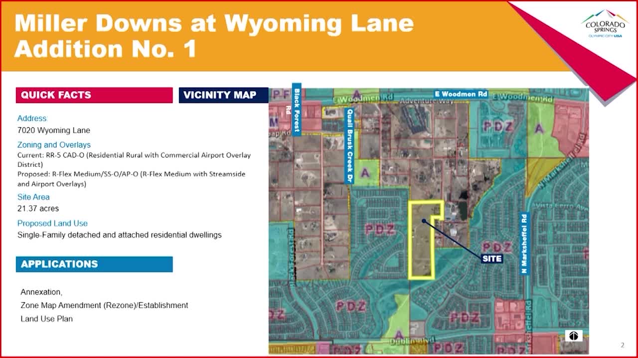
Summary
The commission voted unanimously to recommend annexation, adopt a land‑use plan and establish an R‑Flex Medium zoning for the 21.37‑acre Miller Downs at Wyoming Lane addition, with conditions including a 35‑foot building‑height limit and resolution of a 30‑foot remnant along Wyoming Lane.
The Planning Commission on Aug. 13 unanimously recommended that City Council approve the annexation, land‑use plan and establishment of an R‑Flex Medium zone (with streamside and airport overlays) for the 21.37‑acre Miller Downs at Wyoming Lane addition. Commissioners attached conditions addressing wetlands review, a 30‑foot remnant strip along Wyoming Lane and a maximum building height.
Tamara Baxter, planning supervisor, told the commission the property is currently in El Paso County as an enclave and proposed for single‑family detached and attached residential at a density of 5.2 dwelling units per acre — roughly 110 homes. "What's being proposed density wise is 5.2 dwelling units per acre, which equates to roughly about 110 homes in this development," Baxter said. Staff identified access points and noted Sand Creek and streamside overlay areas that constrain development and require environmental review.
Colorado Springs Utilities development projects manager Brian English summarized utility requirements and capacity. He said the city's reliably met water supply is currently approximately 95,000 acre‑feet/year, with an available de minimis buffer for this annexation and a projected water demand for the site of about 38 acre‑feet/year. English noted Springs Utilities' capital cost estimate to serve the site ranges roughly from $2.3 million to $3.5 million and that annexation petitions must deed groundwater rights to the city per code.
Applicant representative Noel Raymer (Kimley‑Horn) described outreach and changes made after neighborhood meetings, including reducing unit counts by more than 30 units, adding pocket parks and rerouting road alignment to increase buffers to Sand Creek. Kirby Thompson, an adjacent landowner and nursery operator, spoke in support, saying the developer had been sensitive to neighbors and that the project would be a better outcome than other developer proposals the property owner had considered.
Conditions adopted by the commission and included in the staff motion require the applicant to resolve ownership of a 30‑foot remnant along Wyoming Lane before final plat, perform third‑party wetland delineation for the northwest wetland area, and limit building height on the land‑use plan to 35 feet. The package — annexation, land‑use plan and zoning establishment — will be transmitted to City Council for final action.