Get Full Government Meeting Transcripts, Videos, & Alerts Forever!
Get email alerts on the Land Use Development topic
No spam. Unsubscribe anytime.
Developer trims Wildwood plan to 44 homes; committee raises parking, Main Street and drainage questions
Summary
A development team presented a revised concept plan for a 44-unit subdivision in Wildwood on Tuesday night, highlighting a reduction in density, expanded buffering to the south and a Main Street right-of-way dedication; the development and zoning review committee raised questions about visitor parking, pedestrian connections to the adjacent Village Green and the design and aesthetics of proposed stormwater detention basins.
A development team presented a revised concept plan for a 44-unit subdivision in Wildwood on Tuesday night, highlighting a reduction in density, expanded buffering to the south and a Main Street right-of-way dedication; the development and zoning review committee raised questions about visitor parking, pedestrian connections to the adjacent Village Green and the design and aesthetics of proposed stormwater detention basins.
The developer said the current concept reduces the proposal from 55 units to 44 and increases the southern buffer. “The prior plan was 55 units. The current plan is 44 units,” said Mike Doster of the development team. He also said the southern buffer was increased “from 20 feet to 70 feet.”
The committee’s planning director and several council members said they welcomed the design changes but pressed the team on operational details that city staff and safety officials said must be resolved before the project advances.
Why it matters: The site sits adjacent to the city’s Village Green and a planned “unlimited play” playground. How the development connects to Main Street, where visitors will park, and how runoff is detained and landscaped will affect neighborhood access, safety and visibility of the park.
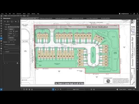
The plan and site features The team described a 6.86-acre site at Old Evertown Road and Crestview Drive (shown in the packet materials), divided into fee-simple lots. Project presenter Dave Volz described two separate drainage watersheds and said the concept includes two detention basins and a separate rain garden to manage stormwater. “There’s really a high point right here…we actually have two detention basins because there’s really two watersheds,” Volz said. He told the committee the basins are preliminary and will be designed to meet Municipal Standards District and city requirements.
Architect William Levinson reviewed unit types and exterior materials. He said the plan includes 12 ranch-style units (two-bedroom, two-bath) and the remainder two-story units with three or four bedrooms; the development team said 32 of the units will include basements and that about half the lots are designed with walkouts or slab foundations. Levinson described intended materials as stone, cementitious siding and architectural accents to meet the town center design manual’s preferences.
Buffers, setbacks and dedications The developer reiterated retention of the previously proposed Main Street dedication — “approximately 37 feet wide” — and said the project will dedicate a 40-foot right-of-way with a proposed interim pavement section of roughly 26.1 feet and sidewalks on both sides. The team said the project provides about a half-acre of common-area buffer adjacent to the property to the south and roughly 100 feet between the backs of the new structures and the nearest existing residence on the neighboring parcel.
Parking, circulation and public safety Several elected officials and staff focused on parking and emergency access. Planning staff and the developer described two enclosed parking spaces per unit (garages) plus driveway aprons. Director Vinich told the committee the proposed 26.1-foot pavement width “allows parking on one side under the fire code,” but cautioned that parked vehicles could impede safe access to driveways and fire movement.
Mayor Gaetano and council members said visitor parking remains unresolved. The developer offered possible visitor-parking clusters in the plan’s internal island or expanded parallel parking near Evertown Road; the team estimated those areas could yield multiple additional spaces if the committee desired. “You could probably get 10 on this side, 10 on that side,” one developer representative said when estimating potential added spaces, while several council members urged a smaller, more targeted visitor-parking solution that preserves green space.
Pedestrian connectivity to Village Green Committee members urged the developer to prioritize safe, legible pedestrian access to the Village Green rather than an informal rear path. Mayor Gaetano recommended routing a sidewalk to the formal park entrance rather than a secluded trail behind the park. Volz confirmed it is “grade wise” possible to add a sidewalk connection from the southern end of the development’s circle to the Village Green and said the team will study connection options.
Stormwater design and basin aesthetics Volz said the basins are preliminary and not yet designed; the team acknowledged they will discuss with the city whether basins will be wet or dry and said there is “plenty of room to do what we want.” Committee members flagged basin aesthetics because the basins border the Village Green; the developer acknowledged the concern and said they will work with staff on design and landscaping.
Access alignment and Main Street coordination The location and construction timing of the proposed access to Main Street generated extended discussion. Council members and public-works representatives said the city has an established Main Street concept, including an ultimate cross-section with a raised median and angled parking in places, and that the development’s access should align with that plan where practicable. The developer said the submitted plan is an interim design that avoids acquiring right-of-way from parcels to the north and that the developer has dedicated the right-of-way shown on the concept. “You can call it an interim plan,” the developer said; a city official said the city has funds budgeted and right-of-way acquisition plans for Main Street in the next two years.
No formal action taken This meeting was an early, informal concept presentation; no zoning decision or permit was requested or granted. Committee members asked the development team to return with more detailed materials, particularly a landscape plan, visitor-parking strategy and engineered detention-basin designs. The only formal motion at the meeting was to adjourn, moved by Councilman Marshall and seconded by Valver; the motion carried.
What’s next Staff said the concept is preliminary and subject to change if it proceeds to formal submission. The department and developer will coordinate on engineering details, right-of-way language, and how the interim road design can or should tie into the city’s Main Street improvements and capital program. The committee noted the public will have additional opportunities for comment during formal planning and zoning and council review stages.