Get Full Government Meeting Transcripts, Videos, & Alerts Forever!
Get email alerts on the General Plan Amendment topic
No spam. Unsubscribe anytime.
Commission recommends changing Brush Lake area from open space to agriculture to clear path for rezones and permits
Summary
Tooele County planners recommended and the commission unanimously endorsed a general plan amendment to change portions of the Brush Lake area from open space to agriculture to enable rezones and building permits for multiple privately owned parcels.
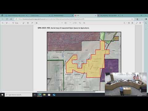
The Tooele County Planning and Zoning Commission voted unanimously to recommend that the county council amend the general plan for the Brush Lake area (GPA2025‑103) from open space to agricultural designation. The change was requested by property owners in order to pursue subsequent rezones and building permits for parcels that do not meet the county’s MU‑40 minimum‑acreage standard.
Planning staff told the commission the amendment is a procedural step: owners of nonconforming parcels must secure a general plan amendment before a rezone can be considered so their parcels fall in line with the general plan. The staff presentation noted the MU‑40 zone requires a 40‑acre minimum; many parcels in the application area are smaller and therefore nonconforming. Staff also said the county’s minimum agricultural zoning has a five‑acre minimum and that floodplain permitting will apply where relevant.
Several property owners addressed the commission. Applicant Jake McArthur and others said the current open‑space designation has made it difficult to obtain building permits, power and other services for existing parcels. Resident CW Thompson said every parcel included in the application is privately owned and asked the commission to allow the owners the opportunity to rezone and regularize their properties. New owner Alan Patt said he purchased his Stockton‑area property in July and needs to replace an existing home; he supported the amendment.
Commissioners asked technical questions about how many parcels are involved, which parcels are legal nonconforming and which pre‑date the cutoff used to determine vested rights. Staff said the cutoff for legal nonconforming status was parcels established as of Jan. 10, 1975; parcels that predate that are vested and can be treated as legal nonconforming. The staff recommendation included a map and a list of parcels; commissioners noted that some land within the broader area is BLM or otherwise outside the applicants’ request and not part of the amendment.
The commission moved, seconded and recorded a unanimous recommendation to the county council. Commissioners and staff emphasized that the amendment itself does not rezone parcels; it allows property owners to file rezones and subdivision or building permit applications consistent with an agricultural designation. Floodplain permits and parcel‑level development restrictions will be handled during subsequent reviews.
The commission closed public hearing with multiple residents speaking in support and said the item will be transmitted to the county council for formal action.