Get Full Government Meeting Transcripts, Videos, & Alerts Forever!
East Point planning staff demonstrate GeoPointe portal and development-design tools
Summary
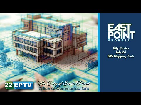
Tere Mohammad, the City of East Point’s new GIS coordinator, demonstrated the city’s GeoPointe mapping portal and related tools at a City Circles meeting, showing how planners, developers and residents can view zoning, permits, floodplains and proposed development scenarios.
Tere Mohammad, the City of East Point’s new GIS coordinator, demonstrated the city’s GeoPointe mapping portal and related tools at a City Circles meeting, showing how planners, developers and residents can view zoning, permits, floodplains and proposed development scenarios.
The presentation focused on practical features: ArcGIS Online as the city’s back end (branded in the presentation as “GeoPointe”), Google Earth and Google Earth Pro for 3-D visualization and street view, FEMA floodplain layers, and a design-generation tool (called “Delve” in the presentation) that produces building-layout options based on zoning parameters such as floor-area ratio, setbacks, green space and parking. Tere Mohammad demonstrated generating multiple design alternatives for a parcel and exporting designs for presentation tools such as SketchUp.
Why it matters: City planners said the portal will make land-use information and departmental data more accessible to residents and potential investors. Kimberly Smith, planning and community development director, said the city’s planning map is maintained on a 20-year horizon and is updated on…
Already have an account? Log in
Subscribe to keep reading
Unlock the rest of this article — and every article on Citizen Portal.
- Unlimited articles
- AI-powered breakdowns of topics, speakers, decisions, and budgets
- Instant alerts when your location has a new meeting
- Follow topics and more locations
- 1,000 AI Insights / month, plus AI Chat