Get Full Government Meeting Transcripts, Videos, & Alerts Forever!
Get email alerts on the Traffic Safety topic
No spam. Unsubscribe anytime.
Torrington presents Safety Action Plan identifying 65 high‑injury locations, urges phased funding and coordination with DOT
Summary
VN Engineers and city staff unveiled a Safe Streets for All–funded Safety Action Plan that maps a 65‑location high‑injury network in Torrington, recommends low‑cost and corridor measures, and asks the city council to adopt the plan so projects can compete for future federal funding.
Nancy Datta, a project lead with VN Engineers, on behalf of the City of Torrington, presented the Torrington Safety Action Plan at a public forum, outlining the results of a Safe Streets for All (SS4A) grant‑funded study and a set of recommendations for reducing roadway deaths and serious injuries.
The plan maps a 65‑location high‑injury network in Torrington — 22 roadway segments and 43 intersections — and recommends a mix of systemwide measures (education, enforcement, signage), corridor treatments for state and local roads, and smaller, lower‑cost countermeasures the city could pursue immediately. Datta said the SS4A grant funded the action plan itself and “this grant was specifically for this action plan. So this grant does not allow to use that money.”
Why it matters: Torrington and the consulting team tied the plan to the city’s Vision Zero commitment. The presentation cited crash data from 2019–2023 for the Northwest Hills region and Torrington: 72 fatal crashes across 21 municipalities in the region, with 20 fatalities in Torrington; the team reported 48 pedestrian crashes with injury and 16 bicycle crashes in town. The city’s stated Vision Zero target — included in the presentation — calls for a 50 percent reduction in traffic deaths and serious injuries by 2030 and elimination of deaths and serious injuries by a date shown in the materials as "02/1935" (not specified in the presentation and unclear from the transcript).
Key findings and recommendations
- High‑injury network: VN Engineers combined crash data and public survey responses (322 survey responses reported) to produce a high‑injury network that concentrates around downtown and the East Main/Target/BJ’s corridor.
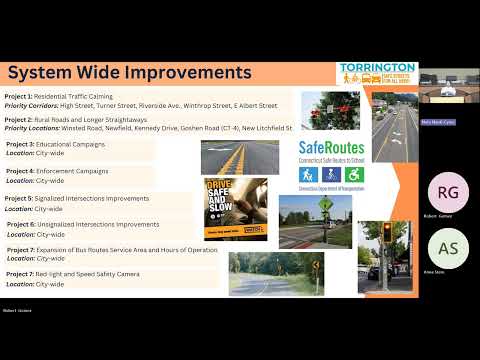
- Systemwide measures: Recommendations include education campaigns, increased enforcement (including discussion of Connecticut’s red light/speed camera pilot), improved signage and retroreflective signal backplates, and consideration of “no turn on red” at locations with heavy pedestrian crossings.
- Corridor and site recommendations: For East Main Street (state road), the team recommended clearer signal and lane signage, new crosswalks at high‑demand locations (for example near Target), and access management near BJ’s to reduce left‑turn conflicts, including converting some access points to right‑in/right‑out and using flexible posts to prevent left turns where appropriate. For Prospect Street (a town road) the plan recommends making pedestrian crossings more visible, installing pedestrian hybrid beacons where appropriate, evaluating lead pedestrian intervals at signals, painting clear stop bars, and adding bicycle facilities or shared‑lane markings.
- Low‑cost, short‑term options: The team emphasized that many effective steps are low cost (signage, pavement markings, bollards, painted curb extensions) and can be phased into the city’s budget or paired with smaller grants, while larger geometric projects such as roundabouts or full corridor reconstructions require substantial funding and CT DOT approval.
Public questions and staff responses
Residents at the forum pressed the team and city staff on costs and implementation. One commenter asked, “How much is left of this grant…?” Datta answered that the SS4A funding supported preparation of the action plan itself and is not available for construction. Several residents said they worry that producing feasibility studies without construction funds leaves the city unable to implement recommendations; others described specific local concerns, including frequent crashes at the Calhoun/Main/Barley Place corner, safety gaps where a bike lane abruptly ends near Bogle School, and a reported history of crashes at Ocean Road and University Drive.
Nate (assistant city planner) said the plan is intended to be a tool for the city to prioritize projects and to qualify for future federal funding: “This plan is sort of a prerequisite to get some of the federal funding as well,” he said. The assistant city planner explained the next steps would be to bring the plan to the city council for adoption, continue work with the technical advisory committee (staff), and use the plan to support future grant applications.
Paul Kunzins, the city engineer, described recent and planned local improvements used as examples of implementing smaller changes: “In order to get all 3 legs to stop, we narrowed everything up,” he said of an intersection the city had tightened with pavement markings and temporary treatments to improve visibility and create safer crosswalks; those temporary markings are planned to become permanent curb lines and landscaping when funding is available. Paul also described a planned multi‑use trail and signal improvements tied to a trail grant that the city is combining with street work.
Coordination and limits of authority
Datta and staff emphasized that recommendations affecting state roads require coordination and agreement with the Connecticut Department of Transportation (CT DOT). The presentation referenced Connecticut’s red light/speed camera pilot as an enforcement option that may not be applicable everywhere, and the team noted that public acceptance plays a role in larger geometric solutions such as roundabouts.
Next steps
City staff and consultants said they will present the plan to the Torrington City Council for adoption, continue coordination among the technical advisory committee (city planner, city engineer, police traffic sergeant, economic development) and pursue funding opportunities for projects at multiple scales. Staff stressed the plan is intended both to identify low‑cost measures the city can adopt and to provide a basis for competing for larger federal or state construction grants.
Ending note
Presenters thanked residents for survey participation and public input; VN Engineers and partner firm VHB were acknowledged for preparing the report. Staff said the plan will inform the upcoming comprehensive plan update and future budgeting for road and pedestrian improvements.