Sammamish maps sidewalk and bike gaps, will prioritize projects using a data-driven score
Get AI-powered insights, summaries, and transcripts
Subscribe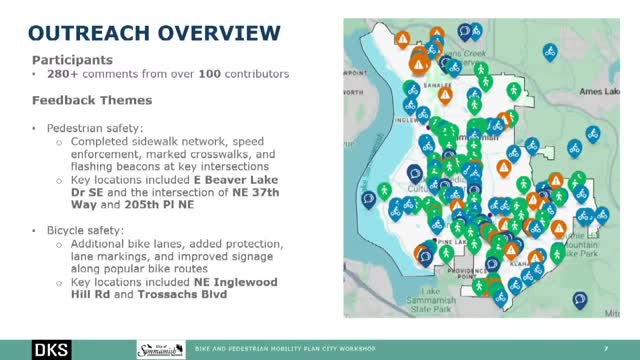
Summary
Consultants presented a GIS-based prioritization that combined sidewalk/bike gaps, traffic stress, crash history, proximity to schools/transit/commercial areas and slope to identify high-need corridors for project recommendations.
Consultants and city staff told a public workshop they used a data-driven GIS scoring method to prioritize bicycle and pedestrian projects based on gaps, level of traffic stress, crash history, proximity to schools and transit, and slope. Wintana Miller of DKS said the analysis started from the priority network identified in the Transportation Master Plan and then evaluated sidewalk and bike gaps on arterials and nearby school access routes. Miller said red lines on the project map show the highest-need links, and highlighted corridors with continued gaps even after planned TIP projects: portions of Southeast 204th Street, parts of 212th, Dutty Hill Road, Northeast Eighth, 240th Avenue Northeast and Kahane Boulevard. Miller and city staff noted Sahale Way (in design) and Louis Thompson (under construction) as projects already reducing gaps. The workshop materials also noted more than 280 comments from the public mapping tool and outreach in February; staff said they will use the scoring to develop a project list for the draft plan and to feed projects into the Transportation Improvement Plan for funding consideration.