Council workshop reviews transit‑supportive development study, mapping tool and corridor examples
Summary
City staff and consultants presented a transit‑supportive development study that maps areas of social need and development readiness, proposes four redevelopment typologies and identifies example sites along city transit corridors; councilmembers asked for earlier distribution of materials, property‑owner outreach and clearer incentive guidance.
Vice Mayor Smith convened a City Council workshop to review a transit‑supportive development planning study led by consultants MKSK with Development Strategies and Nelson ygaard, in partnership with Knoxville Knox County Planning and Knoxville Area Transit (CAT). The study, funded by a federal Areas of Persistent Poverty grant awarded in 2021, presented an interactive mapping tool and four typologies for redevelopment on transit corridors and offered example sites for each typology.
The presentation summarized a mapping index that overlays "development readiness" and "social need" so staff and developers can prioritize corridor investments. Aubrey Weiland of Knoxville Knox County Planning said the tool shows areas where "the darker blue an area is shaded, the greater the development readiness, and the darker pink that an area is shaded, the greater the social need," and that purple areas indicate overlap of both priorities. The map is not public yet but staff said it will be posted on the planning website and the presentation emailed to council.
Why this matters: the study aims to align recent investments in CAT service (including higher‑frequency routes from the CAT Reimagined process) with land use decisions to reduce car dependence, increase daily transit demand and catalyze economic investment and housing near transit. Amy Brooks, executive director of Knoxville Knox County Planning, called the tool an input for the city's upcoming comprehensive plan update and said the study is intended to identify sites where public and private investment could be paired.
Consultants presented four typologies for corridor redevelopment. Aaron Kowalski of MKSK described them as: infill (vacant or underused parcels within built neighborhoods); neighborhood nodes (gateways or intersections that serve nearby residents); plaza redevelopment (surface‑parked shopping centers that could be converted to mixed use); and catalytic sites (larger, sometimes publicly owned parcels that could anchor broader district change). For each typology the team showed precedent images, criteria used to evaluate candidate sites and one local example.
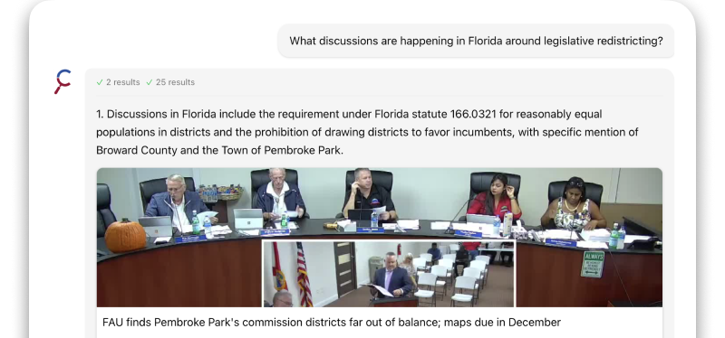
Examples cited in the presentation included: - An infill site off Sutherland Avenue and Liberty Street of about 7–7.5 acres near Riley Foods and the Third Creek Greenway, described as near multiple CAT stops and already seeing some middle‑housing construction. - A neighborhood node at the Magnolia and Cherry intersection (described as roughly a 14‑acre study area) intended to knit neighborhoods to transit stops and improve pedestrian crossings and streetscape. - A plaza redevelopment example near Chapman Highway and Moody Avenue (presenters noted a ~5‑acre example site) that could better connect to adjacent Sam Duff Memorial Park and nearby multifamily housing. - A catalytic, county‑owned building site on Central near Baxter (the former Sears / county building) where presenters suggested adaptive reuse plus surrounding mixed‑use redevelopment and public space.
Presenters emphasized corridor differences: red map lines show routes with 15‑minute service, blue indicate 30‑minute service and fainter lines 60‑minute service. MKSK noted that 15‑minute service is most supportive of daily transit use but the study also looks for opportunities along lower‑frequency routes.
Council members and staff pressed several practical questions. Councilman Roberto said council would have benefited from receiving the presentation sooner; presenters acknowledged the file was emailed during the meeting and said the full materials would be posted online. Councilwoman Thomas and others asked whether the study inventories apparently dormant privately owned parcels (surface parking, underused retail) and whether those owners would be contacted; MKSK said the study used the planning office's quantitative tool to highlight priority areas and that the results and example sites are intended as conversation starters for outreach to property owners and developers.
Council members also discussed implementation levers and timing. Councilman Roberto noted the city's zoning code update made mixed‑use and upper‑floor residences allowable in commercial corridor zoning and asked why corridor development has not moved faster; Amy Brooks and the consultants said the study is intended to identify barriers and next steps (including incentives and outreach) and recommended a working group of staff, stakeholders and developers to follow up. Councilwoman McKenzie asked about incentives; staff said specific incentive recommendations are still to be developed and will appear in the consultant report. During the meeting a grant figure of $364,000 was cited for the federal award; presenters said they would confirm that amount.
Participants discussed related operational issues. Councilman Roberto and consultants discussed "first/last mile" and micromobility options; the CAT representative noted microtransit pilots are appropriate in areas lacking any fixed route service, while higher‑frequency corridors (for example Route 31 and portions of Routes 11, 22 and 41) are priorities for 15‑minute service and accelerated bus planning. Consultants and staff noted corridor ownership (city vs. TDOT/ state) can affect streetscape and pedestrian improvements and thus influence feasibility and timing.
Several council members urged greater urgency and active outreach. Council members described prior corridor studies (the 2022 Opticos analysis and a 2023 council resolution identifying corridor areas) and said many corridor tools and zoning changes are already in place; they urged staff to identify who will lead proactive owner outreach, implementation and coordination among city departments, KCDC and partner organizations. Speakers also raised community‑engagement points: neighborhood meetings, capturing resident preferences so commercial offerings reflect local needs, and ensuring multiple meetings rather than a single forum.
Next steps presented by MKSK and planning staff included finalizing a draft report, further engagement with developers and key property owners, conducting a community survey and using the study as an input to the comprehensive plan. The consultants recommended the city consider a working group to review and prioritize catalytic sites and said the tool could support future grant applications.
No formal votes or ordinance actions were recorded in the workshop; presenters and staff described the session as planning and outreach work leading into the comprehensive plan process.