Get Full Government Meeting Transcripts, Videos, & Alerts Forever!
Get email alerts on the Beach Improvement Washington Street topic
No spam. Unsubscribe anytime.
Work group approves expanded coastal and stormwater studies, allocates $15,000 to SCAPE
Summary
The Washington Street Collaborative Work Group voted to approve revised scopes of work for the Francis Street/ Washington Street beach improvement project and to allocate about $15,000 from a Nantucket Land Bank grant to complete an expanded SCAPE task.
The Washington Street Collaborative Work Group voted to approve revised scopes of work for the Francis Street/ Washington Street beach improvement project and to allocate about $15,000 from a Nantucket Land Bank grant to complete an expanded SCAPE task.
The approval came after a presentation summarizing public feedback collected during the project’s second virtual open house and after consultants described added coastal and stormwater modeling that will inform schematic design. The group’s approval will be forwarded to the Select Board for formal contract authorization at its July 23 meeting.
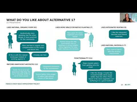
The project team presented findings from Open House No. 2 and an updated schedule. Laura (SCAPE designer) said the public engagement showed community priorities centered on “reducing flood risk to sustain the long term use of Washington Street,” improving natural systems, and creating universally accessible waterfront spaces. She said two conceptual alternatives — the “dune swoop,” a curvilinear dune-and-boardwalk design, and the more angular “beach overlook” — were refined from earlier work and posted for public comment. “The dune swoop came in slightly higher at 3.58 with the beach overlook at 3.15,” she said, summarizing the ranked feedback.
Leah (staff member) read a written public question from resident Jerry Connick and replied that “this project has not yet entered a formal design phase,” and that as the project advances “a site plan review may be completed and made available in accordance with the permitting requirements.” Leah also said the town and the land bank will meet with relevant permitting agencies, including the U.S. Army Corps of Engineers if applicable, and that cost estimates and a project timeline will be developed and shared as the project moves into formal design.
Consultants described new technical tasks added to the schematic-phase scope. Laura said the team has completed additional stormwater analysis with Hazen and Sawyer and will add an integrated stormwater model to evaluate the project’s capacity to manage runoff across several climate scenarios. Joe (coastal modeler, Woods Hole Group) outlined two coastal-modeling tasks: assessing the independent effectiveness of raising the two parcels under study in reducing near-term flood pathways to Washington Street, and using the same model to assess redirected flow to ensure the design does not create unintended impacts on adjacent properties.
Todd (coastal engineer, Par) described the waterfront engineering scope. He said the team will perform a permitting feasibility assessment, evaluate structural and erosion performance using cross-shore modeling, and prepare schematic-level waterfront structure drawings to support a preliminary cost estimate for the benefit-cost analysis. “One of the most critical task[s] will be the permitting feasibility assessment,” he said, noting regulators will need clear explanations of how the proposed elements interact with coastal regulations.
Work group members raised questions and concerns that the design process must address. Speakers flagged sight lines from Francis Street, kayak access and storage, the long-term maintenance and renourishment schedule for dune work, and whether bicycles should be accommodated on new waterfront pathways. One member summarized a common theme: do the work now “right the first time,” because opportunities to rebuild later will be limited. The team said a 16-week schematic design phase is planned after the detailed assessments, and that the schematic deliverables will include a FEMA benefit-cost analysis and an operations and maintenance guide.
During action on the item, a work group member moved to approve the revised SCAPE and Par scopes and the recommended use of the Nantucket Land Bank grant to fund the additional SCAPE task. The motion passed on a roll-call vote with named affirmative votes recorded for Alan Reinhart, Nat Law, Matt Lowell and Mr. McNabb; the meeting record states all present supported the approval. The record notes Par’s contract work is covered by the grant and that the additional SCAPE allocation is about $15,000. Staff said they will prepare a Par contract amendment and bring both the SCAPE contract amendment and the Par contract to the Select Board on July 23 for formal adoption.
Next steps recorded in the meeting: staff will finalize contract documents, coordinate a potential July 25 work group meeting pending consultant review of site data, and targeted project kickoff for consultant work around August 1 if the Select Board formalizes contracts. Consultants also offered to schedule a site visit the week of August 4.
The work group’s action advances the project from concept and public engagement toward technical feasibility and schematic design while adding focused coastal and stormwater modeling intended to quantify benefits, erosion performance, permitting risks and maintenance needs.