Get Full Government Meeting Transcripts, Videos, & Alerts Forever!
Get email alerts on the Climate Flooding topic
No spam. Unsubscribe anytime.
Consultant presents vulnerability assessment showing access and flooding risks for Loxahatchee Groves
Summary
A project consultant for the Town of Loxahatchee Groves outlined results of a completed vulnerability assessment under the Resilient Florida program, saying the town’s surface‑water model shows rising flood depths and access impacts to several critical assets under current and future storm and sea‑level scenarios.
A project consultant for the Town of Loxahatchee Groves outlined results of a completed vulnerability assessment under the Resilient Florida program, saying the town’s surface‑water model shows rising flood depths and access impacts to several critical assets under current and future storm and sea‑level scenarios.
The consultant said the study evaluated nine critical assets, modeled historical and design storms (including a simulation resembling Tropical Storm Isaac and a 2025 100‑year 3‑day event), and produced recommendations such as upsizing culverts, adding outfalls, installing operable gates at Okeechobee Boulevard and improving telemetry. "The project has already started. The data collection has occurred. The modeling is complete," the project consultant said during the meeting.
Why it matters: the model indicates that, while some buildings remain physically protected in a 100‑year event, access to at least one emergency facility would be impeded by inundation. The consultant showed maps of the town under multiple scenarios and highlighted that sea‑level rise and increased rainfall through 2040 and 2070 increase tailwater levels and extend inundation during storms.
Key findings presented include: the model that most parcels are hydraulically connected and share storage; a 25‑year, 3‑day storm adjusted to 12.3 inches was used to approximate Tropical Storm Isaac; a 2025 100‑year, 3‑day event used 17 inches (NOAA basis); projected increases of roughly +2.9 inches for 2040 and about 22.61 inches in 2070 were included; and sea‑level rise increases tailwater by about 1 foot in 2040 and roughly 2.5 feet by 2070 for the C‑51 basin as presented.
The consultant assigned risk levels (1–3) to assets based on depth and duration: for roadways a 100‑foot length underwater at 0–1 foot = risk 1, 1–2 feet = risk 2 and >2 feet = risk 3; similar bands were used for buildings. The presentation noted the fire station would remain structurally protected in the 100‑year scenario but access could be affected by flooding.
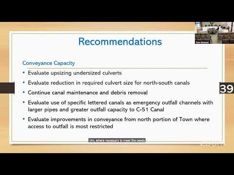
Recommendations the consultant discussed included adding or advancing discharge from secondary outfalls to the C‑51 Canal, upsizing identified undersized culverts, reconstructing select canals to town standards, evaluating large tract storage or attenuation areas, installing operable gates at Okeechobee Boulevard to manage tailwater, and improving telemetry for remote control and monitoring. The consultant also said the team is evaluating coordination opportunities with Palm Beach County and the South Florida Water Management District for reservoir or conveyance options.
The draft report is to be submitted to FEMA and will be finalized after state and FEMA comments and further public or steering committee input. The consultant invited public questions and asked residents to send additional focus areas or local flood observations to the town for consideration. "If you have any questions, comments, or concerns, please please send those into the town so we can review and and get those addressed," the project consultant said.
The meeting was framed as public outreach rather than a formal vote or adoption of specific projects; no motions or formal actions were taken during the session. A town staff member closed the meeting after attendees' questions were addressed.