Get Full Government Meeting Transcripts, Videos, & Alerts Forever!
Get email alerts on the Westbridge Open Space topic
No spam. Unsubscribe anytime.
Weber County planners, developer and commissioners discuss open‑space mapping and potential DWR easement for Westbridge Meadows
Summary
County staff and developer representatives outlined open‑space mapping, park ownership and potential state purchase of a 300‑foot buffer along the Great Salt Lake shoreline for the Westbridge Meadows project; commissioners asked for a development agreement provision to allow time for state negotiations and private matching funds.
County planning staff and the project applicant discussed how open space, future transportation corridors and parkland would be handled in the proposed Westbridge Meadows master plan during a Weber County Commission work session on June 23.
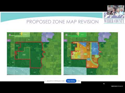
The county’s presentation showed the zoning map colors that mark master‑planned open space and described the minimum open‑space requirement the applicant must meet: “10 acres per 1,000 population,” county staff said. That standard translates to about 10 acres for every 333 dwelling units, staff added.
Why it matters: Commissioners said they want a larger buffer along the Great Salt Lake shoreline than the applicant has proposed and asked for a mechanism in the development agreement to allow the Utah Division of Wildlife Resources (DWR) time to try to acquire additional land for conservation. Commissioner comments emphasized avoiding condemnations and ensuring property owners are made whole if the state purchases easements or fee interests.
County staff said the large polygonal open‑space areas on the plan are intended as regional parks that could ultimately be dedicated to the park district, but that in similar past projects the developer often maintains parks initially and the public agency takes over operations later when it has capacity. The applicant said the developer would reserve a 300‑foot‑wide corridor adjacent to the shoreline for potential future conservation or transportation use and would negotiate in good faith with DWR.
Commissioners and other speakers described asking state lawmakers and agency leaders to support an easement or other acquisition. A commissioner said they had already raised the idea with state legislative leaders and planned meetings with the appropriations chair and the house chair to pursue potential funding. Commissioners discussed a timeline tied to the state budgeting cycle: whether the county should wait through the legislative process and allow roughly a 12‑month window — possibly stretching to July 1 of the following year, the speaker said — for state funding decisions before any county approvals would allow development to proceed.
On transportation and transit, the developer’s presentation showed several potential transportation corridors and two long‑term transit station sites. The applicant said it would set aside a 300‑foot corridor for a future transportation alignment and a separate ~40‑foot corridor adjacent to the Union Pacific tracks that could accommodate a dedicated transit lane (possible bus rapid transit or light rail) or be widened in partnership with the railroad.
Points commissioners requested for the record included: written language in the development agreement that (a) allows a fixed negotiation period after county approvals for state acquisition of a buffer, (b) addresses whether the county or an easement holder would maintain fences and signs, and (c) clarifies how acquisition values would be determined (appraised fee or easement valuations). Speakers also asked the county to explore private matching funds to supplement any state appropriation so the developer would not be left uncompensated.
What was not decided: No formal votes were taken on open‑space acreage, buffer width or specific acquisition commitments. Commissioners asked for another work session to refine the development agreement language before placing a decision on a future agenda.
Community impact and next steps: Staff said open‑space dedication would be phased so that 50% of required open space would be contributed to the river corridor as subdivisions are recorded; the remaining open space could be located elsewhere in the master plan. Staff and the applicant said they will return with development‑agreement language that would memorialize a fixed period for negotiations with DWR and include options for easement or fee purchase, with details on maintenance, fencing and potential wetland exchanges.