Get Full Government Meeting Transcripts, Videos, & Alerts Forever!
Surveyor-historian traces how land claims, railroad and maps shaped Missoula
Summary
At a public presentation, Bill Weichel—who said he is known as "Montana Bill"—reviewed how 19th-century land claims, the Homestead Act, GLO surveys and the arrival of the railroad determined Missoula's early plats, cemeteries, water ditches and industrial sites.
Bill Weichel, a Missoula surveyor and local historian, gave an illustrated public talk describing how land claims, federal settlement laws and the coming of the railroad shaped Missoula’s 19th‑century development.
"As she says in the surveying history world ... I'm Montana Bill because I am the 1 of the few people in the Western United States that actively is involved in surveying history," Weichel said during the presentation.
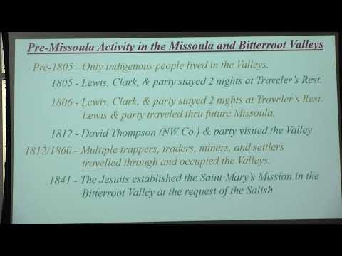
He told listeners that federal laws and surveys drove much of the town’s early pattern. The 1862 Homestead Act, which allowed settlers to claim 160 acres after five years of residence and improvements, and the 1862 Pacific Railroad Act that incentivized rail construction, both figured prominently in his account. Weichel said the General Land Office (GLO) surveys reached the Missoula area around 1870, after earlier “declarations of occupancy” and local filings had already been made by traders and early residents.
Weichel traced the sequence from early trading posts to mills and town…
Already have an account? Log in
Subscribe to keep reading
Unlock the rest of this article — and every article on Citizen Portal.
- Unlimited articles
- AI-powered breakdowns of topics, speakers, decisions, and budgets
- Instant alerts when your location has a new meeting
- Follow topics and more locations
- 1,000 AI Insights / month, plus AI Chat