Get Full Government Meeting Transcripts, Videos, & Alerts Forever!
Get email alerts on the Land Use Subdivision topic
No spam. Unsubscribe anytime.
DRC recommends amended Tanner Flats plat move to planning commission with conditions
Summary
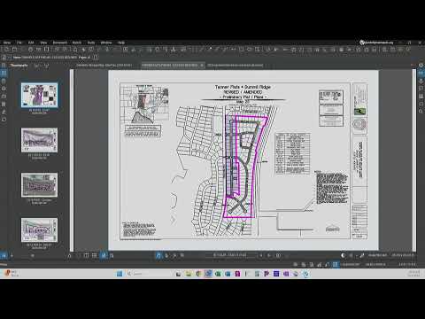
At a May 27 Development Review Committee meeting, staff presented an amended plat for the Tanner Flats subdivision. The DRC voted to forward the application to the planning commission, conditioning the referral on corrections to plan scaling and cul-de-sac/drivable-radius and hydrant placement issues identified by staff and the fire department.
The Development Review Committee on May 27 recommended that an amended plat for the Tanner Flats subdivision be forwarded to the planning commission, with conditions that specified red-line items be addressed before the application is scheduled for planning commission review.
DRC staff said the amendment would change road alignments, dedicate some public open space to the city and add lots within the existing development; staff reported the amendment would create 91 new lots within the development. The site is on the east side of Summit Ridge Parkway between the Cedar Point and Stone Hall subdivisions.
The recommendation matters because it clears the application to advance in the city approval process while requiring fixes the DRC and city departments said are necessary for public safety and technical compliance. The DRC’s action directs applicants to resolve outstanding engineering, fire and utility concerns before the planning commission considers the amended plat.
Planning staff and reviewers walked the committee through technical comments. Aspen, planning staff, noted the DRC is performing a preliminary review and that two existing rights-of-way would be vacated after the planning commission acts. Aspen asked the applicant to verify the scale on the phasing plans so lot dimensions can be measured.
Fire Department staff said the department was concerned about the drivable radius at two cul-de-sacs and requested the cul-de-sac geometry follow the International Fire Code so that there is sufficient drivable space. “Requesting it to follow the IFC and give us 96 feet of drivable space,” the Fire Department staff said. City standards and specifications were described in the meeting as calling for a 20-foot standard in the relevant sheet; the DRC flagged that the applicant must resolve how the proposed cul-de-sac geometry meets both the fire department’s access requirements and the city’s standards.
The fire reviewer also asked that a proposed hydrant east of an intersection be relocated westward, closer to the intersection, to better align coverage with 250-foot hydrant-radius requirements; staff said additional hydrants may be required so that the 250-foot service radius encompasses lot frontages.
Engineering staff flagged utility requirements on dead-end water lines running west from the south intersection (Summit Ridge Parkway/Auburn Lane). The engineering comments noted that PI and culinary lines will need air-relief valves and hydro blow-offs at those locations. Jason Kelly (listed in the meeting as “Jason Kelly, public courts”) confirmed snow-load easement notes are present on the plans and asked staff to ensure the snow-loading cross-section detail and notes are included.
After department comments, a DRC member moved to recommend the amended plat be forwarded to the planning commission, conditioned on addressing the red-line items, particularly scaling and cul-de-sac issues, before the planning commission agenda. The motion was made by Alan, DRC member, and seconded by Mike, police representative. The committee voted in favor and the motion passed. The DRC also approved minutes from its April 22 meeting before adjourning at 10:11 a.m.
The next step is for the planning commission to review the amended plat; the DRC’s referral is conditioned on the applicant’s resolution of the technical comments identified in this meeting.