Get Full Government Meeting Transcripts, Videos, & Alerts Forever!
Whatcom County project: floodplain to expand, models show higher tides and larger river floods ahead
Summary
At a virtual workshop, Whatcom County staff presented modeling showing larger coastal and river flood hazards through mid- and late-century, and mapped infrastructure vulnerability including roads, treatment plants and utilities.
At a virtual Whatcom County workshop, Chris Elder, senior planner with Whatcom County Public Works, said county modeling shows shoreline flooding and bluff and river erosion will affect more land and infrastructure in coming decades. "The whole goal of this effort is really to try to collect a lot of the best available science," Elder said, explaining phase 2 of the Whatcom Future Shorelines project.
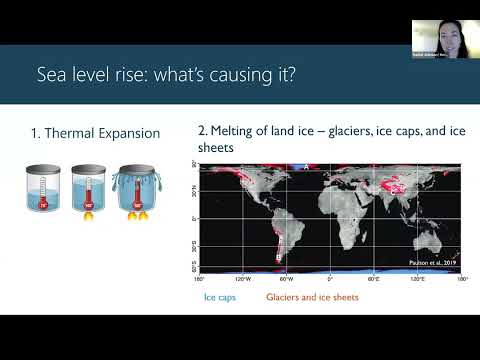
County presenters said current mapping shows about 82 square miles in the county reside in today’s floodplain and that modeled scenarios driven by sea level rise and changes in precipitation could expand that footprint to more than 100 square miles in coming decades. Officials cited U.S. Geological Survey coastal modeling and University of Washington Climate Impacts Group work to set planning scenarios.
The project team said the county used USGS CoSMoS (Coastal Storm Modeling System) and other regional studies to produce compound-flood modeling that combines sea level rise…
Already have an account? Log in
Subscribe to keep reading
Unlock the rest of this article — and every article on Citizen Portal.
- Unlimited articles
- AI-powered breakdowns of topics, speakers, decisions, and budgets
- Instant alerts when your location has a new meeting
- Follow topics and more locations
- 1,000 AI Insights / month, plus AI Chat