Get Full Government Meeting Transcripts, Videos, & Alerts Forever!
Get email alerts on the Transportation Land Use topic
No spam. Unsubscribe anytime.
Missoula unveils draft West Broadway vision; planners weigh 3‑lane vs. 4‑lane tradeoffs
Summary
Consultants and city staff presented a draft vision for West Broadway in Missoula and sought public feedback Wednesday evening on design options that would reshape the corridor’s streetscape, pedestrian access and parking.
Consultants and city staff presented a draft vision for West Broadway in Missoula and sought public feedback Wednesday evening on design options that would reshape the corridor’s streetscape, pedestrian access and parking.
The draft centers on extending downtown into a Riverfront Triangle, improving connections to the Clark Fork River with a Riverfront Greenway, and creating several activity nodes (including a proposed village center at Burton and a Safeway node). Transportation staff and consultants laid out three cross‑section scenarios and intersection options and discussed tradeoffs between an enhanced three‑lane roadway and a potential four‑lane section in the future.
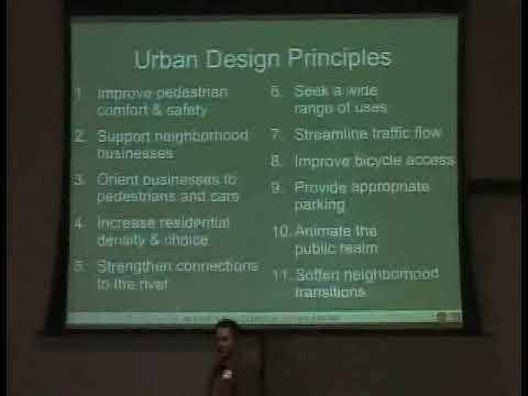
The consultants said the corridor should be “a safe, vibrant, and attractive multimodal transportation gateway to Downtown Missoula,” with streetscape, safety, connections and land‑use strategies guiding design. “We have a presentation that will be partly familiar … and partly fairly new,” Brian, a city staff facilitator, told the meeting. Transportation planner Jeff Key, of Robert Petch and Associates, described the technical tradeoffs and capacity estimates.
Why it matters: West Broadway is a primary approach to downtown with existing redevelopment interest, nearby anchors including the hospital and supermarket, and an opportunity to link downtown to the river. Choices about lane configuration, right‑of‑way acquisition and access management will shape safety, pedestrian comfort, development potential and where public funds are spent.
Most important technical points
- Cross‑section options: The team presented (a) an enhanced three‑lane section that preserves the current center turn lane with raised medians and streetscape; (b) a four‑lane urban section using narrower traffic lanes and a planted median; and (c) variants on parking and bicycle accommodations.
- Capacity guidance: The consultants offered planning‑level capacities — roughly 20,000 vehicles per day for a well‑managed three‑lane urban section and in the mid‑20,000s for a four‑lane section — noting these are planning approximations that vary with access control and driver behavior. Jeff Key said the historic planning thresholds have been 18,000 for three lanes and 24,000 for four lanes but that recent studies show three‑lane facilities can sometimes carry more with good access management.
- Lane, median and bike dimensions discussed: existing travel lanes were described as 12 feet, proposed narrow lanes of about 10.5 feet were shown for the four‑lane option, a current center median of about 14 feet was noted, and a 5‑foot bike lane was the baseline used in the diagrams (some participants urged wider bike lanes and door‑clearance buffers where on‑street parking is retained).
- Right of way and feasibility: The team used a 100‑foot typical right‑of‑way assumption for detailed sections and reported variable existing right‑of‑way along the corridor (examples below 100 feet in places). Consultants recommended acquiring consistent right‑of‑way in constrained areas to preserve options and avoid forcing future property removal after redevelopment.
- Parking and access management: On‑street parking was envisioned as short‑term, time‑restricted spaces that support local businesses; the preferred long‑term approach for private parking is access behind buildings, reached from cross streets, combined with an access management plan to reduce driveways along the corridor.
- Intersections and special cases: Consultants presented concept geometries for major intersections including West Broadway at Orange, Burton, Front and Russell. The Russell‑Broadway interchange is already the subject of an environmental impact statement; consultants said small changes (reducing turn radii, limiting certain turning movements or moving ramps off the route for trucks) could reduce crossing distances and the overall footprint compared with the EIS alternative.
Public comments and equity concerns
Meeting participants asked about pedestrian sight lines (especially for people using wheelchairs or children), accessibility of signal pushbuttons, the visibility of pedestrians with added landscaping and whether roundabouts are appropriate in locations with disabled walkers. A commenter asked that landscaping be kept low where mid‑block crossings are likely; consultants agreed to reinforce that design language.
Implementation and next steps
The consulting team presented a phased implementation matrix: 0–2 years for detailed planning, right‑of‑way identification and parking management strategy work; 3–5 years for land assembly and catalytic projects; 6–10 years to continue acquisitions and implement major public realm projects; and 11–20 years for longer‑term roadway redesign if traffic volumes and development justify it. The draft plan will be posted online and the team said it will return to present a revised draft to the City Council in mid‑May. Staff invited written comments and left display boards and simulations on the wall for closer review.
Quotes limited to meeting participants
“We have a presentation that will be partly familiar … and partly fairly new,” Brian, a city staff member, said at the start of the meeting.
“As a transportation planner … the traditional traffic analysis may not be appropriate,” Jeff Key of Robert Petch and Associates said during the presentation, urging “innovative thinking about traffic” and presenting the capacity ranges noted above.
Ending
Consultants urged stakeholders to review the draft plan materials, submit comments through the project website and attend the next public presentation to City Council. The team emphasized that the preferred concept balances pedestrian‑oriented development, riverfront access and a multimodal corridor while preserving options to adjust lane configuration if long‑term traffic volumes change.