Get Full Government Meeting Transcripts, Videos, & Alerts Forever!
Get email alerts on the Fema Flood Map Update topic
No spam. Unsubscribe anytime.
Mayor’s resilience office and DPP brief committee on FEMA flood‑map updates and insurance implications
Summary
City officials outlined FEMA's updated Flood Insurance Rate Maps (FIRMs), outreach and the 90‑day appeal window; they urged homeowners in newly mapped areas to shop for flood insurance because new insurance requirements may apply to federally backed mortgages when maps become effective.
Officials from the Mayor’s Office of Climate Change, Sustainability and Resiliency and the Department of Planning and Permitting briefed the committee on the Federal Emergency Management Agency's preliminary Flood Insurance Rate Maps (FIRMs), the outreach program, and the appeals and next steps.
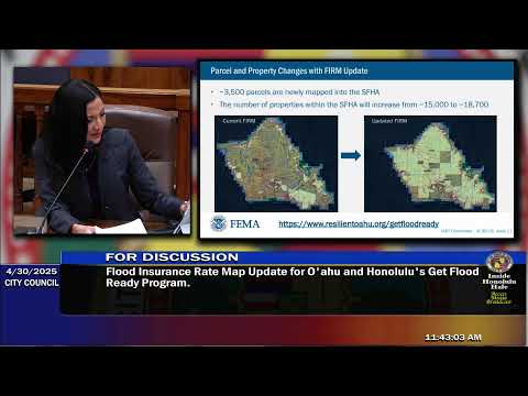
Ben Sullivan, executive director and chief resilience officer, explained that the National Flood Insurance Program (NFIP) requires communities to adopt FIRMs to make federal flood insurance available. He said FEMA’s preliminary maps studied hundreds of stream miles that were previously unassessed and that the update moved roughly 3,500 parcels into the Special Flood Hazard Area (SFHA) while reclassifying about 55,000 parcels from undetermined (Zone D) into lower‑risk unshaded Zone X.
Sullivan said the NFIP's Risk Rating 2 pricing system (implemented in 2023) customizes premiums to each property; the city cannot provide exact premiums and residents should obtain quotes from insurance agents. He cited a state NFIP coordinator estimate that the average NFIP policy premium on Oahu was $676 annually as of January 29, 2025, but emphasized premiums vary widely by property. Newly mapped properties are eligible for a sliding newly‑mapped discount that phases down toward the actuarial rate over time.
The formal 90‑day appeal period for the preliminary maps runs March 13 through June 10, 2025; appeals must include technical data certified by a licensed engineer or surveyor to challenge FEMA’s flood elevations or boundaries. FEMA will review appeals and issue a Letter of Final Determination; once the letter is issued there will be a six‑month compliance window before the maps are effective and lenders may require flood insurance on federally backed mortgages for newly mapped properties.
Sullivan outlined city outreach (postcards, open houses, social media, library materials) and recommended residents use the city’s interactive map or FEMA’s site to check property status; staff also provided contact emails for DPP, the resilience office and FEMA. Committee members asked about individual notices and data sources; staff said DPP pulled parcel-level information from FEMA data and that the city mailed notices to affected parcels and residents in borderline cases.
Sullivan and staff encouraged early homeowner engagement with agents to explore NFIP and private-market options, and to consider the newly mapped discounts and other resources available through the city.