Get Full Government Meeting Transcripts, Videos, & Alerts Forever!
Get email alerts on the Comprehensive Planning topic
No spam. Unsubscribe anytime.
La Center moves ahead on downtown and Timon Landing subarea plans as county study puts expansion at risk
Summary
City staff and consultants presented draft subarea plans, zoning changes and an implementation list intended to support housing, jobs and a new downtown plaza. Council and the planning commission voiced concerns about reduced parking, vendor rules, and a Clark County resource-land study that could block proposed UGA expansion.
La Center — At a joint meeting April 23, city staff and planning consultants from WSP presented draft subarea plans and accompanying zoning and code changes for downtown and Timon Landing intended to speed redevelopment and meet 2045 housing and jobs allocations assigned by Clark County.
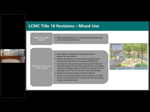
The subarea work includes a new downtown mixed‑use code, a new high‑density residential district, a downtown gateway overlay, and a Timon Landing neighborhood commercial overlay; code changes would also rework parks/open‑space zoning, allow limited concessionaire uses near a proposed waterfront boardwalk and reduce a minimum parking requirement by up to 10% in a small downtown area. "For land use, the primary goal here with supporting policies for downtown is to concentrate mixed use density in the downtown core to support access to diverse housing opportunities, local shops, and town history," said Alec, a WSP planner presenting the draft updates.
Why it matters: The city faces a state and county requirement to show capacity for housing (including units affordable at ≤80% area median income) and jobs through 2045. City staff said adopting the subarea plans and code now would enable grant applications and implementation projects even as the county’s review of agricultural/resource lands may delay or constrain the city’s planned urban growth boundary (UGA) expansions.
Code and zoning highlights
- Mixed use and residential: The draft downtown mixed‑use code would promote vertical mixed‑use buildings (ground‑floor commercial with residences above). WSP proposes a new high‑density residential district that applies many existing medium‑density (MDR) design standards to higher densities.
- Minimum project size: The existing 2.5‑acre minimum project area for medium‑density residential would be removed in the subareas so smaller downtown parcels can develop; other minimum lot‑size rules would remain in force.
- Commercial overlays: A downtown gateway overlay is proposed to allow hospitality, commercial recreation and other uses close to the riverfront. The draft would also repeal a narrow C‑3 cardroom overlay and fold card rooms into a C‑1 downtown commercial zone while allowing other C‑1 uses in former cardroom parcels.
- Vendors and waterfront access: The code would allow limited concessionaire structures (for example, rental booths or kiosks) in low‑density residential areas inside the downtown subarea only if they are within a half‑mile of an approved pedestrian boardwalk to the East Fork Lewis River, and subject to building‑height and sign standards.
- Parks/open space: The existing parks and open‑space code would be relocated and consolidated under an urban public district designation for city‑owned parks; staff said the change is intended to make zoning and code language consistent, not to remove parkland.
Implementation projects and infrastructure
Consultants and staff presented an action list of regulatory and capital projects to support the plans: sewer collection and stormwater master plan amendments, a potential sewer tie‑in for Timon Landing, stormwater detention ponds (including a proposed downtown detention facility and one mentioned for Pollock Park), intersection upgrades and new pedestrian and bike facilities, a proposed pedestrian plaza and boardwalk to the waterfront, and a potential phased parking structure (staff said a garage, if needed, would be built in phases and could be up to two stories initially). Jody, a WSP planner, summarized the action plan as regulatory, infrastructure and parks projects that together would implement the subarea vision.
Debate and concerns
Council members and commissioners pressed staff on parking, market viability and the risk of encouraging residential uses to the detriment of ground‑floor commercial. Council member Leija asked about the parking reduction language; staff clarified the provision would allow up to a 10% reduction in required parking only in a small brown‑shaded downtown area and only when certain offsets (for example, a garage) are present. Several elected officials cautioned that reducing parking could hamper retail activity unless off‑street or shared parking solutions are available.
Council member Boyle and others also asked about vending zones and existing vendor spaces at parks and gravel lots; staff said they would double‑check current allowances and include existing vendor locations in the subarea materials if necessary.
County resource‑land study and expansion risk
The meeting also focused on a parallel process at Clark County: the county council directed staff to complete an agricultural/resource‑land analysis to determine whether specific parcels the city proposed for UGA expansion can be de‑designated from resource/agricultural use. City staff and consultants said the county agreed to do the study but set a fast deadline (staff cited a September 1 target). Alec told the council the county‑led study is required by state law and that even a favorable study must then be approved by the county council; if the study finds the parcels remain resource lands, the city’s proposed expansions could not proceed.
Staff described the parcels at issue as site‑specific owner requests, some of which have been in urban reserve for decades. Staff and council members asked for coordinated, written support to the county and said they expect a county work session that may include La Center and Ridgefield. "The importance of the sub area plan is to get that adopted into the current comprehensive plan so we can get grant funding as soon as possible before the comp plan might get pulled up held up because of this whole county level process," Alec said.
Votes at a glance
- Consent agenda — approved (unanimous vote called; details not read into the transcript).
- On‑call planning services (WSP) — council authorized an extension/authorization of the on‑call planning services contract with WSP, increasing the contract to a not‑to‑exceed $110,000 to cover review work through December (staff described about $95,000 as passthrough for plan review and roughly $15,000 for staff support). Motion carried.
- WSP subarea contract amendment (Amendment #3) — council approved a $25,000 increase to the WSP subarea plan contract to add scope: 20‑year transportation analysis inclusion and capital project documentation so the subarea plan can be used for grant applications. Motion carried.
- Resolution to initiate right‑of‑way vacation (La Center Road / Paradise Park Road area) — council adopted a resolution to set a public hearing for May 14 to consider vacating a small triangular parcel and accepting a roughly equal dedication from a private developer to support a planned roundabout at that intersection. Resolution passed.
What the city will do next
Staff said the draft Environmental Impact Statement (EIS) for the subarea work would be published to start a 30‑day public comment period and that red‑line legislative code amendments would follow. Staff and consultants asked for and received direction to schedule more joint sessions with the planning commission and the county; several council members asked staff to prepare formal letters and a resolution documenting the city’s position before upcoming county hearings. City staff said the county’s resource‑land study timetable and a county work session are now the key external deadlines to watch.
Ending
City staff and WSP emphasized that adopting the subarea plans would allow La Center to apply for grants and advance capital projects even as the county process continues. If the county study or council action blocks the targeted parcels, staff said they would return to the council with options; if the study is favorable, the city intends to proceed toward final adoption and implementation of the downtown and Timon Landing subarea plans.