Get Full Government Meeting Transcripts, Videos, & Alerts Forever!
Geophysical survey at Calhoun Cemetery finds 62 burial anomalies; 52 unmarked locations staked
Summary
A Vanderbilt research team using ground-penetrating radar mapped the Calhoun Cemetery near Nolensville Pike and identified 62 anomalies consistent with burials, marking 52 previously unrecorded locations for descendants and preservation partners to review.
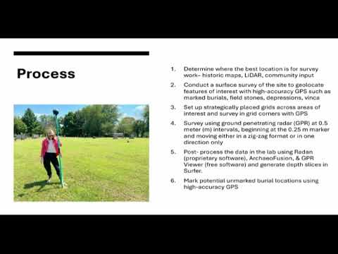
Natalie Robbins, program manager at the Vanderbilt Institute for Spatial Research (VISER), told the Metro Historical Commission that a ground-penetrating radar (GPR) survey of Calhoun Cemetery identified 62 subsurface anomalies consistent with burials and documented 13 monuments with readable inscriptions.
Robbins said the survey, conducted with support from the Preservation Society of Nashville and the Nashville Historical Foundation, combined surface mapping and GPR transects to locate both marked and likely unmarked interments. "This is a noninvasive technique. We're not disturbing anything at a site like this," Robbins said while describing how GPR reflections and depth slices help distinguish features such as tree roots, grave shafts and concrete-lined burial boxes.
The survey team recorded 13 legible monuments, 10 surface depressions, four broken or unreadable monuments, two concrete markers, two potential field stones and two features described in the report as "grave boxes." Robbins said the GPR interpretations produced 62 anomalies that the team judged to be burial-related; 10 of those anomalies…
Already have an account? Log in
Subscribe to keep reading
Unlock the rest of this article — and every article on Citizen Portal.
- Unlimited articles
- AI-powered breakdowns of topics, speakers, decisions, and budgets
- Instant alerts when your location has a new meeting
- Follow topics and more locations
- 1,000 AI Insights / month, plus AI Chat