Get Full Government Meeting Transcripts, Videos, & Alerts Forever!
Get email alerts on the Flood Hazard Overlay topic
No spam. Unsubscribe anytime.
Salem staff update flood-hazard overlay to reference new FEMA maps effective July 8, 2025
Summary
City planning staff presented minor text changes and a map update to Salem’s Flood Hazard Overlay District, saying the new FEMA maps will not add or remove homes from flood zones and will take effect July 8, 2025; council closed the hearing and referred the ordinance back to the planning board.
Tom Devine, senior planner from the San Juan planning department, told a joint meeting of the Salem City Council and Planning Board on April 16 that the proposed revision to the Flood Hazard Overlay District ordinance mainly updates the ordinance to reference FEMA’s revised flood maps and adds a few state-requested text changes.
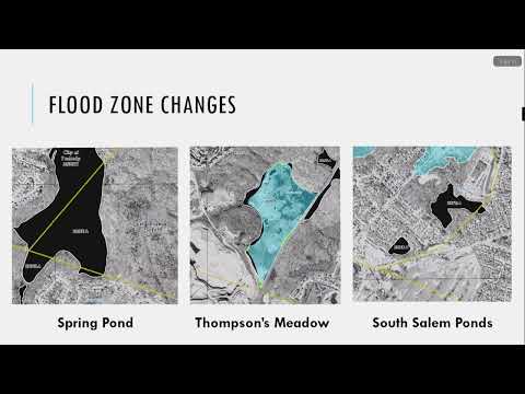
The changes are limited, Devine said, and do not add or remove any homes from FEMA flood zones; they are intended in part to keep the city eligible for its residents to buy federal flood insurance. He said the new maps go into effect July 8, 2025, and that several inland surface-water areas in Salem will be adjusted on the maps, including Spring Pond behind the Highland Avenue Walmart, portions of Thompson’s Meadow, and South Salem ponds near Vinant Square. Devine said some required wording from the state model ordinance was omitted in last year’s update and the state flood office requested minor textual corrections.
The presentation noted the city’s 2024 adoption of a broader Coastal Resiliency Overlay District and a major flood-management zoning update. Devine proposed the ordinance become effective on the same date as the maps, July 8, 2025, rather than on adoption. He said the state floodplain office also requested adding recreational vehicles to zones where the FHOD applies and requiring adequate drainage be satisfied through other permits that have measurable standards, such as subdivision or stormwater permits.
Councilors and planning board members asked no substantive questions during the public-session discussion, and no members of the public spoke for or against the changes. After a motion to close the hearing and a motion to refer the ordinance to the Planning Board for formal recommendation, the council closed the hearing and referred the matter for review.
Resources cited by staff included FEMA’s Flood Map Service Center (msc.fema.gov) and flood insurance information at floodsmart.gov. Staff provided contact information for follow-up questions.
The council’s action on April 16 was procedural: closing the public hearing and referring the proposed FHOD amendment to the Planning Board for its review and recommendation; the council did not adopt the ordinance that night.