Get Full Government Meeting Transcripts, Videos, & Alerts Forever!
Get email alerts on the Geology topic
No spam. Unsubscribe anytime.
Geologist Glenn White traces Calaveras County’s deep-time geology and gold history
Summary
At an Angels Camp Museum Foundation event, Glenn White, a geologist affiliated with Columbia College, led an illustrated talk describing Calaveras County’s geology from ancient seafloor rocks to Pleistocene glaciation and the region’s gold-mining history.
Glenn White, a geologist who teaches at Columbia College, gave an illustrated talk at an Angels Camp Museum Foundation event describing the deep-time geology of Calaveras County and how those processes concentrated gold in the region.
White told attendees that “this rock story goes back about 400,000,000 years” and used rock specimens and maps to explain how plate tectonics, subduction of the Farallon plate, and subsequent volcanism and uplift produced the mix of phyllite, greenstone, marble and granitic rocks found in the foothills.
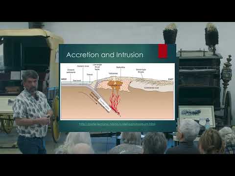
White said California’s geologic history is driven by plate tectonics and accretion: seafloor sediments and volcanic material were scraped off and plastered onto the continent’s edge, then metamorphosed. He described how seafloor mud became slate and phyllite, submarine lavas became greenstone, and limestone became marble after burial and metamorphism.
He explained that magma generated during subduction produced granitic bodies deep underground and late-stage hydrothermal fluids carrying silica and small amounts of gold migrated along faults and precipitated as quartz and gold-bearing veins. “As this heated material is rising through the preexisting rock, the fluids that carry a little bit of gold and a little bit of silica in solution are moving up paths of least resistance, so fault lines,” White said.
White traced younger events that reshaped the region: explosive rhyolitic volcanism about 20 million years ago that blanketed valleys with ash, then lower-silica effusive flows about 10 million years ago that capped former river channels (producing the inverted topography visible at Table Mountain). He noted these lava flows sometimes traveled more than 60 miles from their source.
The talk included field references within and near Calaveras County: Table Mountain, the Stanislaus River and Central Hill Channel, Jamestown, Parrotts Ferry and Camp 9, the Cataract Quarry, Douglas Flat, Carson Hill and the Morgan Mine. White discussed how placer and drift deposits, capped by lava or volcanic ash, concentrated gold and led miners to pursue surface and underground ore.
White summarized mining history in the Mother Lode region: roughly 13,000 gold mines and about 128 million ounces extracted historically in the broader district. He described large recoveries from local mines such as Carson Hill — where a 195-troy-pound mass of gold was reported — and noted the Morgan Mine’s extensive workings.
He also passed around specimens and pointed out local rock types visitors can see along Highway 4 and Highway 49, including serpentinite (the state rock), mariposite and pillow-lava structures preserved as greenstone. White cautioned that some local names and informal usages vary among collectors and miners.
White closed by emphasizing that geologic interpretation is ongoing as new data and methods refine understanding: “It’s at the end of the story now that it’s a work in progress. The active processes are lifting the plates up, wearing them off. We’re making new discoveries, better explanations.” Ending his talk, he invited questions from the audience.