Get Full Government Meeting Transcripts, Videos, & Alerts Forever!
Get email alerts on the Land Use Overlay topic
No spam. Unsubscribe anytime.
Powhatan planners review Highway Commercial Overlay District draft, focus on Route 60 setbacks and shared access
Summary
Planning staff reviewed a draft Highway Commercial Overlay District (HCOD) targeting the Route 60 corridor, proposing setbacks measured from the Route 60 centerline, a monument landscaping zone, required cross‑parcel connections and VDOT coordination. Staff said the commission will advertise the ordinance for a March public hearing.
Planning staff presented a draft Highway Commercial Overlay District (HCOD) for the Route 60/Anderson Highway corridor and asked the Powhatan County Planning Commission for feedback before a planned advertisement for a March public hearing.
The draft applies to the Route 60 corridor between Maidens Road and other segments identified in the draft and would layer an overlay district on top of existing commercial zoning. Staff described three primary elements: (1) setbacks measured from the Route 60 centerline and VDOT right‑of‑way, (2) a 75‑foot “monument zone” intended for landscaping and monument signage with a narrower 50‑foot option if a denser landscape buffer is installed, and (3) a 30‑foot connection zone intended to provide two‑way travel and cross‑parcel parking/loading to encourage interparcel circulation instead of multiple direct cuts onto Route 60.
Why it matters: staff said the overlay is intended to preserve a more uniform appearance along the corridor as development occurs, reduce the number of driveway cuts, and make future cross‑parcel circulation easier for motorists and emergency access.
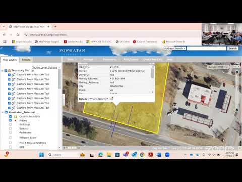
Key details from staff’s presentation: - Setbacks and measurement: the draft measures setbacks from the Route 60 centerline (VDOT centerline) rather than from private property lines; a 100‑foot dedication area adjacent to the centerline was discussed for possible future public uses such as sidewalks, turn lanes or utilities. Staff said using the centerline is a stable reference for long‑term measurement. - Monument zone and building setbacks: the draft calls for a 75‑foot monument/landscape zone in front of the building setback. With a double‑density landscape buffer (more numerous, larger plantings), the monument zone could be reduced by 25 feet, effectively moving buildings 25 feet closer to the road if the owner chooses the enhanced landscape treatment. - Parking and hard surfaces: staff said the monument zone is intended only for landscaping and signs; parking and hard surfacing would generally not be allowed within that zone. Parking could begin at the rear of the monument zone; staff showed an aerial example where a building sits landward of the 75‑foot building setback while existing parking extends closer to the road under the current site layout. - Canopies and canopies at gas stations: staff advised that gas canopies are treated as structures/buildings for purposes of the setback and would be subject to the building setback standard in the draft. - Nonconforming buildings: the draft would treat existing nonconforming buildings differently; staff said parcels already developed would be required to bring sites into compliance when the principal building’s footprint expands by a specified threshold (staff cited a 25% expansion trigger as an example) or when a use changes. - Cross‑parcel connections and access: staff said the HCOD would emphasize shared access and cross connections. The draft requires new development to provide interparcel connections and use shared or consolidated entrances where feasible, and it anticipates coordination with VDOT on driveway design, turn lanes and site access based on trip‑generation traffic analyses. - Administrative review with modification process: most projects under the draft HCOD would be reviewed administratively, with applicants able to request modifications or relief to the standards; unusual cases could be elevated for review by the Board of Supervisors.
Commissioners and members of the public raised practical questions about how the standards would apply to small, already‑developed parcels and to existing businesses. Staff said the draft contains a nonconforming‑structure section intended to address older or small parcels, and that applicants could pursue modifications where strict compliance is infeasible. Staff also showed GIS and aerial examples to illustrate how the setback and landscape buffers would look on existing parcels.
Next steps: staff said the draft will be revised to clarify wording (setback references, permitted uses within the monument zone, and utility locations) and will be brought back for final edits. Staff indicated the planning commission would advertise the HCOD for public hearing at its March 4 meeting if the commission is ready to move forward.