Meriwether County approves EagleView aerial imagery contract after debate over cost, access and privacy
Loading...
Summary
The Meriwether County Board of Commissioners approved a contract with EagleView to capture aerial imagery for the county, locking in a multi‑year price while leaving the second flight optional. The decision followed a lengthy presentation and public discussion about cost, privacy and uses for appraisal and emergency response.
MERIWETHER COUNTY, Ga. — The Meriwether County Board of Commissioners on Feb. 10 approved a contract with EagleView to capture new aerial imagery of the county, after a 90‑minute presentation and an extended public and commissioner discussion about cost, privacy and operational value.
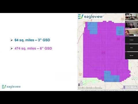
Lucas, an EagleView representative, told the commission the company responded to the county’s request for proposals “to capture imagery for Meriwether County” and described the firm’s oblique (side‑angle) and ortho (top‑down) imagery, integrated software and analytic tools. He said the proposed program would combine higher‑resolution 3‑inch imagery for more developed areas with 6‑inch imagery for rural areas and would include a disaster‑response option.
The imagery proposal, Lucas said, was priced as two flights over six years to lock in rates; EagleView’s two‑flight total was $193,005.85. The company offered a one‑flight option priced at $96,007.92 — which the county finance staff presented as roughly $32,002.64 per year when amortized over three years.
Why it matters: Commissioners and staff said updated imagery could reduce field time for the tax assessor, speed appraisal work and give 911 dispatchers more situational context. EagleView’s tools include Changefinder — a change‑detection product that compares building outlines between base‑year imagery and later flights to flag new structures, demolished structures or changes in square footage.
Discussion and concerns: Several commissioners and members of the public raised privacy and access concerns. Commenters and commissioners said taxpayers pay for public services and questioned who should be allowed to view high‑resolution, oblique images of private land. Commissioners also debated whether the county needed the full oblique capability or whether a single orthophoto flyover would suffice to identify unrecorded structures for tax purposes.
EagleView addressed access controls and resolution limits. Lucas said the company’s software can restrict who may view oblique imagery and that the processing and delivery software are included with imagery delivery: “This software is included with the imagery delivery. So, all of our oblique imagery and ortho imagery when we fly, we automatically upload that imagery to a server that is then provided to you through this software.” He also said the oblique/ortho capture is performed using the same aircraft and cameras and that the main cost differences are from processing and resolution rather than flight operations.
Scope and technical details presented to the board included: - Proposed coverage: 64 square miles at 3‑inch resolution (more developed areas) and 474 square miles at 6‑inch resolution (rural areas). - Disaster response: up to 200 square miles of imagery capture for qualifying events at no cost or reduced cost depending on circumstances. - Changefinder: automated comparison between years (example given: base imagery 2025 vs. follow-up in 2028) to surface likely additions or demolitions for appraisal follow up.
Board action: After debate and an earlier failed motion to deny the proposal, a commissioner moved to accept the EagleView proposal and the board voted to approve the contract with the modification that final execution be subject to legal review. The approved arrangement preserves the county’s option to forgo a second flight later if funding is not appropriated at that time.
Votes at a glance (other formal actions taken at the same meeting): - Cane Creek bridge/rail crossing: commissioners voted to reject a single bid of $385,113 for repair/replacement and directed staff to pursue alternatives (including evaluating alternative county‑maintained access) and to consider rerunning the RFP. - ACCG safety coordinator resolution: commissioners approved the standard ACCG resolution (pending legal review) to designate a county safety coordinator and qualify for insurance discounts from ACCG/IRMA. - July 4 contract for entertainment: commissioners approved contracting a band for the July 4 celebration (fee $3,850) pending legal review and vendor acceptance of contract edits.
What’s next: County staff and legal counsel will finalize contract language with EagleView and return with any edits for the chairman’s signature. Staff will also revisit the Cane Creek crossing after further review of alternative access and CSX requirements, and will process the ACCG safety resolution and the July 4 contract through legal review as directed.
Sources: Presentation by Lucas (EagleView representative); statements and motions recorded during the Meriwether County Board of Commissioners meeting, Feb. 10, 2025.