Get Full Government Meeting Transcripts, Videos, & Alerts Forever!
Get email alerts on the Coastal Resilience topic
No spam. Unsubscribe anytime.
Nantucket committee advances planning for downtown neighborhood flood barrier as homeowners raise groundwater and cost concerns
Summary
Town staff presented a concept for an integrated downtown neighborhood flood barrier that would combine raised roadways, bulkheads, berms and nature-based measures. Homeowners and committee members urged attention to groundwater, stormwater and financing; the committee set quarterly focus meetings to continue public engagement.
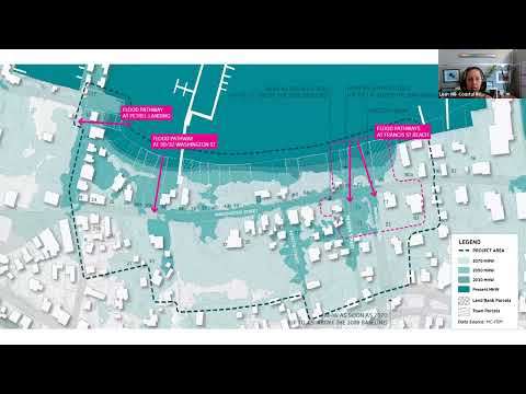
Leah Hill, the Town of Nantucket coastal resilience coordinator, outlined a proposed downtown neighborhood flood barrier on Jan. 28, saying the concept responds to updated NOAA projections and the Massachusetts Coastal Flood Risk Model and would be implemented in phases over 10 to 15 years.
Hill told the Coastal Resilience Advisory Committee that the barrier concept, drawn from recommendations 2-2 and 2-6 in the town's Coastal Resilience Plan, would combine raised roadways, raised wharves, berms, reinforced dunes and selected deployable gates while preserving access to key facilities such as Steamboat Wharf, Straight Wharf and the Town Pier. “We’re planning for the worst and hoping for the best,” she said, describing the town’s recommendation that departments and consultants use the NOAA high sea-level-rise scenario for planning.
The recommendation responds to local flood projections that show daily high-tide flooding increasing in the downtown core: Hill noted NOAA gauge data and explained why the town is using the Massachusetts Coastal Flood Risk Model (MCFRM) — which incorporates tides, storm surge, wave run-up and future storm probabilities — as the town’s “best available” flood mapping. She said a simple linear calculation using NOAA’s 4.01 millimeters-per-year figure from the island tide gauge gives roughly 9.3 inches between 1965 and 2024, but that the MCFRM and NOAA scenarios are the appropriate planning inputs.
Why it matters: the town’s risk assessment cited downtown priorities including the Steamship Authority (Steamboat Wharf), the U.S. Coast Guard station, Stop & Shop, High Line Cruises and National Grid. Hill said the CRP’s preferred design flood elevation for the downtown barrier is 8 feet NAVD88 — chosen to be above projected mean monthly high water as soon as 2070 — and that the town will recommend consistent design elevations to avoid creating local low points where water would concentrate.
Public comment and committee discussion centered on two recurring concerns: groundwater and costs. Several waterfront homeowners said surface protections may not be sufficient if groundwater rises under houses. Tony Robinson, incoming president of the Brant Point Association, said a recently installed neighborhood rain garden halted a chronic puddling problem at his corner: “When the rain garden went in … we have had no flooding at all,” he said. Multiple committee members and residents urged that groundwater and stormwater be studied and incorporated into designs. Hill said the town lacks an island-wide groundwater model but has asked the Nantucket water company and others to develop site-specific data; she also said groundwater considerations are being incorporated into the Easy Street and Francis Street Beach projects’ design elements.
Cost, timing and scope also drew repeated remarks. Hill said the CRP includes high and low cost estimates for a full downtown buildout and that a high-end estimate for the downtown concept is about $170 million; she said the CRP lists a target implementation year of 2050 for broader buildout but that priorities and schedules will be refined as design and funding progress. Committee members and residents urged early, phased work on critical links — Hill said near-term Phase 1 should focus on Easy Street between Straight Wharf and Steamboat Wharf — and recommended outreach to property owners about options including elevation, relocation programs and individual mitigation.
The committee set a procedural direction: members endorsed holding focused public meetings on the downtown neighborhood flood barrier on a quarterly basis, and staff said they would convene targeted outreach so private property owners and neighborhood groups can coordinate on design flood elevations, funding needs and staged implementation. Hill said the town is preparing a guidance memo on recommended design flood elevations for waterfront owners and that the Francis Street Beach improvement and Easy Street projects are moving toward 30% design this spring under existing grants.
Quotes in context: “Groundwater is not included in either the NOAA bathtub model or the MCFRM,” Hill said in response to questions; “in order to determine groundwater risk, you really need to hire a hydrogeologist for your particular property,” she added. Committee members and residents repeatedly pressed for clearer funding pathways and earlier pilot work on high-risk links such as Washington Street and Easy Street.
What’s next: Town staff said Francis Street and Easy Street will advance to roughly 30% design this spring and will need further funding and permitting before construction. The committee agreed to quarterly focused sessions on downtown barrier topics and public outreach; Hill said she will continue to coordinate grants, stakeholder briefings and design guidance for property owners.
Ending: The discussion continued into stakeholder testimony from Brant Point homeowners and others, and CRAC members said they would use forthcoming focus sessions to map financing options, coordinate with permitting bodies and refine phased implementation to reduce disruption to ferries and essential downtown services.