Planning commission moves to align zoning with Monroe 2044 plan, proposes citywide rezone and map adjustments
Loading...
Summary
Planning staff presented a Phase 1 citywide rezone to implement the Monroe 2044 comprehensive plan, proposing to eliminate much of the R‑4 zoning, increase many areas to R‑7, add mixed‑use designations in targeted corridors and remove a Transportation zoning district.
Planning staff on Monday outlined the first phase of implementing the Monroe 2044 comprehensive plan, proposing a citywide rezone that would remove the R‑4 (four dwelling units per acre) designation across much of the city, increase large swaths to R‑7 (a higher maximum density), and convert specific areas to mixed‑use designations intended to allow attached housing and limited commercial uses.
Kate, a planner with the city, told the Planning Commission that Phase 1 focuses on “low‑hanging fruit” to bring zoning into consistency with the adopted future land use map. Staff said the proposed actions include changing residential R‑4 parcels to R‑7 in several neighborhoods (including Friedlands and Foothills), creating mixed‑use general or neighborhood designations north of U.S. 2 and along parts of Main Street/State Route 2, and removing the Transportation zoning district that currently covers right‑of‑way land along the U.S. 2/State Route 522 corridors.
The city’s presentation emphasized that many existing developments already exceed an R‑4 density under planned residential developments (PRDs); staff said the rezone reflects built conditions and would increase permitted maximum density but does not create minimum density requirements. “Most of those developments are greater density than 4 units per acre already,” Kate said of the Frylands and Eaglemont areas.
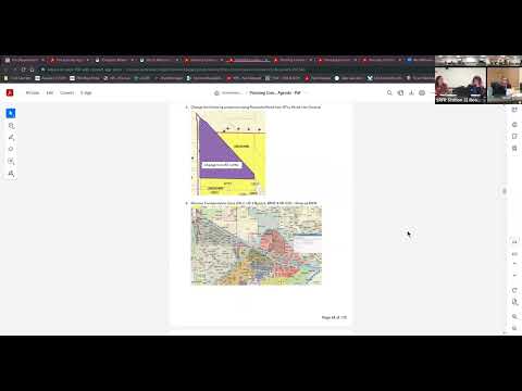
Staff described several targeted map corrections being proposed as part of Phase 1. One correction would rezone a small triangle of parcels formerly used by a roofing company on North Kelsey back to general commercial, restoring the zoning consistent with how the site has been used. Another change would redesignate the site currently used as a food bank from residential to mixed‑use neighborhood to align it with adjacent public‑use properties such as the Boys & Girls Club, the senior center and a nearby park.
The Transportation zoning district would be removed from the code, staff said, because it covers right‑of‑way where typical development cannot occur and can create confusion in code interpretation. Staff said they will follow up with the city attorney to confirm how right‑of‑way jurisdiction should be handled in the municipal code.
Staff also discussed the airport overlay that currently limits height and intensity in a large portion of the city. Kate said the planned unit development (PUD) that has discussed buying airport property has not closed escrow; if the property is sold and the airport closed following state and federal procedures, the council could repeal the airport overlay but any change to citywide height limits would require a follow‑up code amendment.
A public hearing on the proposed Phase 1 rezone was scheduled as tentative on February 24; staff said additional refinements and legal review (including consultation with the city attorney and state reviewers) are needed before formal action is taken.
Commissioners asked about specific map fixes and whether the changes would alter the city’s land capacity for housing and commercial uses. Staff replied the council removed two areas from mixed‑use earlier in the process but that there remains sufficient capacity to meet the plan’s 2044 targets, and that the city regularly updates its comprehensive plan (typically every 10 years) so future adjustments are expected.
The presentation included references to specific code chapters and the packet pages where proposed municipal code amendments appear; staff said some chapters would see only limited changes (for example, elimination of R‑4 references), while others (definitions, bulk standards, and the zoning map chapter) will show detailed edits.
The commission did not take a final vote on the rezone at Monday’s meeting; staff said the item will return for additional review and public hearing once legal and interagency reviews are complete.