Get Full Government Meeting Transcripts, Videos, & Alerts Forever!
Get email alerts on the General Plan topic
No spam. Unsubscribe anytime.
Auburn council reviews Auburn 2045 land‑use map and annexation steps for four study areas
Summary
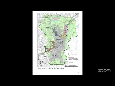
City staff presented proposed Auburn 2045 general plan map changes and explained the annexation process, focusing discussion on four study areas — Lincoln Way, Bowman, the Highway 49 commercial corridor and the western flank toward Ophir Road — and announced two public workshops in March.
City staff on Tuesday outlined proposed land‑use changes in the Auburn 2045 draft general plan and walked the council and public through the legal and fiscal steps required to annex county land into the city. Staff emphasized that the exercise is a 20‑year policy map — not a detailed annexation plan — and asked for council direction on four study areas where designations or future annexation could be considered.
The presentation covered: (1) Lincoln Way, where staff proposed changing parcels currently shown as county commercial to a mixed‑use designation that would permit residential over commercial and could allow higher densities in certain housing site proposals; (2) Bowman, where staff recommended retaining commercial designations rather than the county’s draft change to extensive mixed use; (3) the Highway 49 commercial corridor and adjacent parcels through North Auburn, where staff again recommended keeping commercial to preserve sales‑tax‑generating uses and targeted redevelopment sites; and (4) the city’s western flank from the recent Collins annexation toward Ophir Road, an area of large rural parcels and potential traditional annexation interest.
Why it matters: the general plan map establishes how the city will plan for growth and identifies areas likely to be annexed, which in turn drives environmental review, municipal services reviews (MSR) and fiscal analysis required before annexation can proceed. Sean (city staff) told the council that annexations begin with the general plan update and sphere‑of‑influence planning, that a municipal services review and a negotiated tax‑sharing agreement with the county are required before a Local Agency Formation body will process an application, and that "if we were to annex Target the city would get 0 of that sales tax money for 25 years but we get a 100% of the problems and providing the services." The council discussed the tradeoffs between adding housing capacity and preserving commercial land to support public services.
On specific points raised by council members and members of the public: county housing sites referred to as site 71 and 72 were noted by staff as being proposed at about 30 units per acre; a property owner who said he owns two parcels on Lincoln Way asked whether his proposed 74‑unit project could proceed or needed to wait for the general plan and EIR — staff replied that property‑owner initiated annexations can proceed but that the municipal services review and any tax‑sharing agreement must be addressed and that the current draft map shows lower density on his parcels (about 5 units per acre) unless the council directs a different land‑use designation now so the EIR can evaluate it.
Council members split their preferences by area: several supported mixed use along Lincoln Way to preserve flexibility for residential over commercial, while a number of council members urged keeping Bowman and the Highway 49 corridor predominantly commercial to protect sales tax and employment uses that help fund city services. For the western flank, council discussion focused on infrastructure constraints, topography and the presence of large parcels and the cemetery district; staff noted sewer trunk lines run nearby and that this is a more typical area for traditional annexation efforts.
Staff clarified process and constraints several times: the sphere of influence defines where the city is allowed to plan for potential growth but does not itself annex land; the Local Agency Formation commission (LAPCO, referenced in the meeting) will not process an annexation application until a tax‑sharing agreement is signed and a municipal services review is completed; a 50% protest threshold can stop an annexation before an election; and state rules require the city to plan for its sphere of influence in the general plan. Council and staff repeatedly framed the current work as a policy step to set preferred land‑use designations and begin environmental review rather than immediate annexation actions.
Public outreach: staff announced two public workshops to gather community input on the draft maps and proposals: March 5 from 6 p.m. to 8 p.m. and March 8 from 10 a.m. to noon, both in the Rose Room. Staff said outreach and publicity for the workshops were beginning immediately.
Next steps and status: staff said the draft map changes and any council direction will feed into the city’s EIR and general plan adoption timeline; council members also asked staff to continue negotiating with the county and to consider larger annexation areas in some cases to avoid piecemeal service boundaries. No formal council action or vote was taken during the discussion; the meeting functioned as an input session for staff and the upcoming environmental review.
Ending: councilmembers and members of the public encouraged balancing preservation of Auburn’s “charm” with redevelopment opportunities, and several urged the city to plan proactively to influence future development along its borders rather than cede decisions entirely to the county. Staff said they would return with revised maps and the EIR scoping as the next steps.