Get Full Government Meeting Transcripts, Videos, & Alerts Forever!
Get email alerts on the Coastal Resilience topic
No spam. Unsubscribe anytime.
Town and Land Bank Present Two Concepts to Reduce Flooding at Francis Street Beach
Summary
Town coastal resilience staff and land bank representatives presented two conceptual designs Jan. 17 to reduce flooding through Francis Street Beach that regularly reaches Washington Street, a major corridor between downtown and the harbor.
Town coastal resilience staff and land bank representatives presented two conceptual designs Jan. 17 to reduce flooding through Francis Street Beach that regularly reaches Washington Street, a major corridor between downtown and the harbor.
Leah Hill, the town’s coastal resilience coordinator and a project manager, told the Nantucket Historical Commission the project is “a collaboration with the town, the land bank, and [other partners]” and that “the main purpose of this project is to reduce flood risk on Washington Street.”
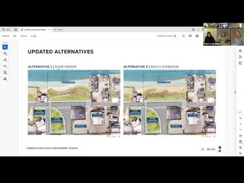
Nut graf: The work group overseeing the Francis Street Beach Improvement Project is considering two early alternatives — a “dune swoop” and a “beach overlook” — both of which would create an elevated dune system with an embedded flood wall and native plantings. The group plans to pick one alternative to advance to 30% design; that design will be the basis for later Historic District Commission, Conservation Commission and other regulatory reviews.
Project team members described the two concepts as functionally similar but different in circulation and appearance. Vince (Natural Resources Department staff) described the dune swoop: “the path rises up to reach elevation 8, which again is about 4 feet high,” and said the team has placed posts and flagging on site to show that proposed height. Project staff emphasized the designs shown are conceptual and that materials and detailed features remain to be decided during design and permitting.
Both alternatives include embedded seawalls that the team said would be buried within a dune-like profile rather than visibly exposed; both are intended to be ADA-accessible with ramps and stairs. Project staff also said they are exploring stormwater management measures on adjacent parcels (including town-owned Saltmarsh parking lot and two inland landing parcels) to reduce stormwater runoff and add infiltration capacity. The team noted possible work to rehab existing outfall pipes, install backflow preventers and reduce impervious surface to stop harbor water from entering drains that now allow tidal water to flood the road.
Public engagement to date and next steps: project leaders and the land bank reported about 125 people attended two public presentations earlier that week. The project’s online feedback survey is open through Jan. 21 at 8 p.m.; staff said meeting recordings and the questionnaire are on the town project webpage and that the work group will compile public feedback and select which alternative to advance at its next meeting.
Commissioners and preservation stakeholders raised access questions: presenters said kayak access and current informal desire lines are being considered and that any kayak landing will need to respect the property boundary between town and land bank parcels. Commissioners also emphasized the importance of retaining beach access for people and kayakers and said the visual character of the area matters because Nantucket’s landscape contributes to the island’s historic identity.
No permit decisions were made at the meeting. Staff said the selected alternative will proceed to 30% design and then to the Historic District Commission, Conservation Commission and other regulators for permitting review.
Ending: Project staff asked the commission and the public to complete the survey by Jan. 21 and noted the design will return for further review; they said many details — materials, exact access routes and stormwater designs — will be refined during the 30% design and permitting process.