Get Full Government Meeting Transcripts, Videos, & Alerts Forever!
Get email alerts on the Annexation Zoning Kerrville topic
No spam. Unsubscribe anytime.
Kerrville planning commission backs annexation of 263‑acre tract with mixed R‑1/R‑2 zoning
Summary
The Kerrville Planning and Zoning Commission on Jan. 2 recommended annexing 263.28 acres into the city limits and approving mixed R‑1 and R‑2 zoning, following public comment about traffic, drainage and wildlife.
The Kerrville Planning and Zoning Commission on Jan. 2 recommended that City Council annex 263.28 acres into the city limits and approve a mix of R‑2 (medium‑density residential) for most of the tract and R‑1 (lower‑density single‑family) for two limited areas: tax parcel 17441 adjacent to Comanche Trace and an approximately 3‑acre stretch of riverfront across Highway 173.
The action followed a staff presentation and a public hearing in which the applicant described a conceptual plan for single‑family homes, and nearby residents urged tighter limits on density and protections for drainage, traffic safety and wildlife habitat. The commission’s recommendation will go to City Council for final action.
Why it matters: Annexation obligates the city to extend utilities and public services and triggers studies and permitting — including an adequate facilities plan, drainage analysis and a TxDOT‑required traffic study — before the developer can advance to preliminary plat and construction. The developer’s concept anticipates a multi‑year buildout that could add roughly 1,000–1,200 lots, creating ongoing demands on roads, water and drainage systems.
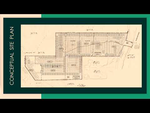
City staff summarized the request as an annexation with an R‑2 zoning designation and presented a conceptual site plan showing collector streets connecting to Highway 173 and a proposed arterial to link 173 with Highway 16. City staff (Drew) said the site is outside current city limits, that no water or wastewater engineering has been completed yet, and that TxDOT will require a traffic analysis because the development would access a TxDOT road. Drew said staff recommends approval as consistent with the city’s comprehensive plan and zoning policies and noted that the city code prohibits an increase in drainage runoff impact from new development.
The applicant, Ashley Fairmont of the law firm Killing Griffin & Fairmont, spoke for the developer identified in the record as Dr. Horton. Fairmont said the proposal is for single‑family homes on 45‑foot lots under R‑2 zoning (the R‑1 standard, by contrast, uses 50‑foot lot widths). Fairmont said the concept shows roughly 1,200 lots on a 10‑year buildout and that the developer expects homes in the 1,500–2,500 square‑foot range aimed at younger or starter families. She said the plan reserves riverfront acreage for community amenities rather than residential lots and anticipates open‑space detention areas to address drainage.
Residents raised several concerns during public comment. Al Cox, who identified himself as a nearby property owner, cited the city’s 2050 Comprehensive Plan and said the plan’s guidance for the area (Strategic Catalyst Area 10) favors rural or estate living with lower densities; he asked the commission to protect existing residents and suggested designating the riverfront acreage as AG/Outdoor Tourism instead of R‑2. Dr. Ross, who lives near the site, and Regina Cox, who also lives nearby, warned about known drainage and standing‑water areas, noted the presence of underground springs, and said increased traffic would threaten wildlife and create safety problems along curves on Highway 173.
Several commissioners said they shared the concerns about drainage, traffic and future density if the property were zoned R‑2 across the entire tract. Commissioners discussed whether the commission could require lower density at annexation or whether limits would need to wait until later land‑use approvals; staff said an adequate facilities plan is required before preliminary plat and that variances typically require demonstrated hardship and thus are not a reliable way to change base zoning standards.
During the meeting the applicant offered an amendment: to designate tax parcel 17441 (adjacent to Comanche Trace) and the approximate 3 acres on the Riverside/riverfront as R‑1, leaving the remainder of the property as R‑2. Commission members discussed that change and its likely effect on lot counts and affordability. A commissioner made a motion to recommend annexation with R‑1 zoning for parcel 17441 and the Riverside acreage and R‑2 for the remainder; the motion was seconded, approved by voice/raised hands and recorded as passed.
The commission recorded no roll‑call vote with named tallies in the transcript. Staff emphasized that many engineering questions — including water and sewer capacity, exact traffic mitigation, and drainage solutions — must be addressed in subsequent technical studies before subdivision plats or building permits would be approved.
The item will next go to City Council for consideration. Commissioners also noted upcoming public meetings on the comprehensive plan update scheduled Jan. 22, including an evening public session at Arcadia Live Theater.