City preview: new Meridian public-art GIS map to show murals, sculptures and traffic-box art
Get AI-powered insights, summaries, and transcripts
Subscribe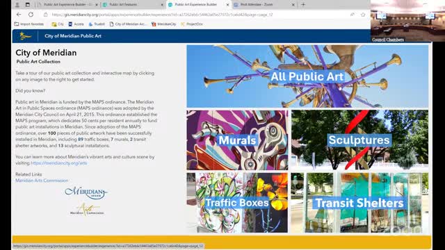
Summary
City GIS analyst Hayden Smith demonstrated a redesigned public-art map on the Meridian website that lets users browse murals, sculptures, traffic-box art and transit-shelter installations with photos, locations and links.
Hayden Smith, a GIS analyst with the City of Meridian, gave a live demonstration of a redesigned public-art map intended for the Meridian website, showing commissioners how users will find murals, sculptures, traffic-box art and transit-shelter installations.
Smith walked the commission through the site’s splash page, layers that toggle by artwork type, and an interactive sidebar that scrolls to selected works. “If you click on any of those, it brings you to that page on the map,” Smith said, showing that the tool will zoom to a selected artwork, display a full-screen image and offer related links and contact information.
Why it matters: the map centralizes public-art inventory and aims to make pieces more discoverable to residents and visitors. Smith said the “all public art” tab lists works alphabetically while individual-type tabs sort most recent first.
Commissioners asked practical questions about the inventory and upkeep. Commissioner Lizzie Taylor asked whether the map could identify traffic boxes that do not have artwork; Cassandra (staff) replied that identifying unwrapped boxes is handled by the public-art committee and planning staff, and that the city conducts an annual check for cracking, peeling or fading to prioritize rewrapping or replacement. Smith said the map will be dynamic to user location and include a “find my location” feature.
Marketing and outreach: Cassandra said the map will be added to the Meridian public-art page and the city’s marketing team will handle social-media outreach to publicize the new resource.
Timing: Smith said the site is close to launch; staff did not provide a specific publish date in the meeting.
The commission invited feedback from members and said Cassandra will accept suggested edits after launch so staff can keep the inventory current.