Get Full Government Meeting Transcripts, Videos, & Alerts Forever!
Whatcom County tutorial shows how to measure parcel acreage with Adjudication Resources web map
Summary
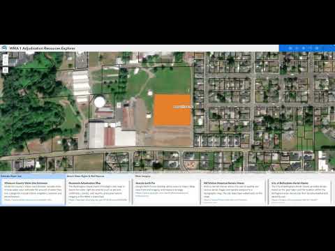
A Whatcom County Public Works staff member demonstrated how to use the county’s Adjudication Resources Explorer web map to measure parcel acreage and print results for Washington water-right adjudication filings.
A Whatcom County Public Works staff member demonstrated how to use the county’s Adjudication Resources Explorer — the county’s free, public “web map” — to measure parcel acreage for water-right adjudication filings in an online tutorial video.
The demonstration, presented in a recorded tutorial, showed how to open the tool from the county homepage, select layers and units, draw a polygon around a parcel and read the area measurement. The presenter used the Linden Fairgrounds as an example and measured a lawn area of 3.17 acres.
The tutorial focused on steps users commonly need when filling out adjudication paperwork:…
Already have an account? Log in
Subscribe to keep reading
Unlock the rest of this article — and every article on Citizen Portal.
- Unlimited articles
- AI-powered breakdowns of topics, speakers, decisions, and budgets
- Instant alerts when your location has a new meeting
- Follow topics and more locations
- 1,000 AI Insights / month, plus AI Chat