Get Full Government Meeting Transcripts, Videos, & Alerts Forever!
Get email alerts on the Historic Preservation topic
No spam. Unsubscribe anytime.
ODOT presents plans for Van Buren Bridge interpretive station; commissioners and public weigh location, flood risk and visibility
Summary
Kristen Strauss, an ODOT representative, presented proposed locations and display options for the Van Buren Bridge’s salvaged pony truss and large turning mechanism and asked the Corvallis Historic Resources Commission and members of the public for feedback on siting, flood resilience and interpretation.
Kristen Strauss, the ODOT representative presenting the agency’s Section 106 mitigation work, outlined plans to display salvaged elements from the Van Buren Bridge and invited public feedback on design and placement.
Strauss said the Section 106 memorandum of agreement with the State Historic Preservation Office (SHPO) sets several mitigation items tied to removal of the bridge, including an updated downtown walking tour, multiple property documentation and several interpretive pieces. “We have the historic American engineering record... we’re waiting on the final report for that,” Strauss said. She described the interpretive projects that remain under design as the pony truss exhibit and a station for the bridge’s turning mechanism.
Why it matters: the bridge components are large and heavy, the site floods periodically, and the city parks department will be responsible for long‑term maintenance. Decisions about placement and treatment will affect public safety, construction logistics and how visitors experience the artifacts.
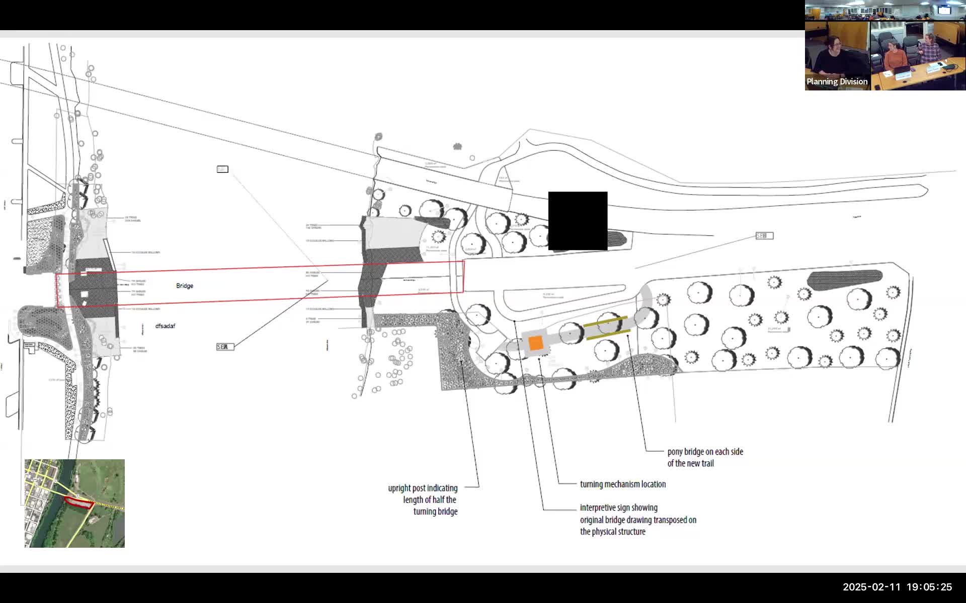
ODOT’s design proposal and current status ODOT staff presented an initial site plan that locates the interpretive station on the east side of the river, south of the bridge, with connections to an existing multi‑use path and Orleans Park. Strauss said the pony truss element is about 60 feet long and roughly 8 feet tall; the turning mechanism measures about 7 feet high and 23 feet wide. The agency’s near‑term deliverables include completion of HAER (Historic American Engineering Record) documentation, a video series and archaeological reporting; the bridge key has already been donated to the local museum.
Strauss said the turning mechanism and the pony truss are listed separately in the MOA but are being considered as a combined interpretive experience: “We’re kind of visioning it as 1 interpretive station.” She described several display options under consideration: placing the mechanism horizontally with a cutaway and protective mesh, installing it vertically so viewers can look up into the gears, cutting it into smaller sections to reduce footprint and provide interior visibility, or locating a see‑through interpretive panel on a retaining wall that would align a model of the complete bridge with the physical artifact.
Public and commissioner priorities raised in discussion Meeting participants emphasized three recurring priorities: 1) ways for visitors to see the internal gearing so the mechanism’s operation is legible; 2) flood resilience and maintenance; and 3) preventing climbing or vandalism.
- Flooding and elevation: Several commenters and Strauss noted the east‑side site floods periodically. ODOT staff said artifacts would sit on substantial concrete pads and that design will consider elevation to reduce frequent inundation. Parks staff have requested designs that limit climbability.
- Visibility and circulation: Commissioners and members of the public supported locating the station where it is visible from the main bike/walking path while permitting a short detour to circulate around the artifact. Strauss described path options that allow through‑traffic to continue while offering a short loop for visitors to view interpretive panels and the artifact up close.
- Interpretation techniques: The group favored approaches that help visitors imagine the full bridge span without requiring the full footprint. ODOT presented a proposal for a transparent interpretive panel mounted on a retaining wall; when a visitor stands at a marked spot, the panel would visually align an artifact portion with an image or model of the full bridge. Participants also suggested augmented‑reality or video animations (QR codes) showing the bridge opening, and smaller physical models or 3‑D printed demonstrators for programs and school groups.
Logistics and timing Strauss said ODOT is aiming to align installation with the contractor’s end of work on the bridge so construction crews (Hamilton) can complete restoration and — where feasible — do portions of the exhibit work while mobilized, reducing duplicate crane/lift costs. She estimated the bridge construction work will continue roughly a year to a year and a half and said the ODOT team hopes to have final interpretive design far enough along to coordinate with the contractor’s demobilization.
Maintenance and ownership ODOT confirmed the city would be responsible for ongoing maintenance after installation; ODOT staff said they will explore what direct support or restricted funding ODOT can provide because federal mitigation money has spending rules. Parks staff raised graffiti and climbability as maintenance and safety concerns; participants recommended raised platforms, fixed concrete bases and limited public access to interior spaces.
Next steps ODOT is collecting public feedback through an online survey and in‑person open houses during the month‑long comment period. Strauss said interpretive text and final panel language would come later in design; she also said staff will post summaries of public comments and report back to the commission as the design advances. The HAER final report and the archaeology reporting are expected later in the year.
Ending Commissioners and the public asked ODOT to prioritize designs that make the mechanism’s inner workings visible, reduce flood exposure of interpretive elements where practical, and minimize opportunities for climbing and vandalism. ODOT committed to returning with refined siting and design proposals after the public comment period.