Get Full Government Meeting Transcripts, Videos, & Alerts Forever!
State Water Board advisory group outlines Phase 2 of California wastewater needs assessment, pauses groundwater scoring
Summary
The State Water Board outlined Phase 2 of a statewide Wastewater Needs Assessment in October 2025, detailing parcel-level mapping of unsewered properties, separate inadequacy-and-risk scores for sewer and permitted facilities, solution matching and statewide cost modeling, and a funding-gap and affordability analysis — while pausing a proposed statewide groundwater-nitrate scoring product.
The State Water Resources Control Board (via an advisory group meeting in October 2025) outlined Phase 2 work on a statewide Wastewater Needs Assessment that will map unsewered parcels, score systems and facilities for inadequacy and risk, match potential solutions and estimate costs, and produce a five-year roadmap for ongoing work.
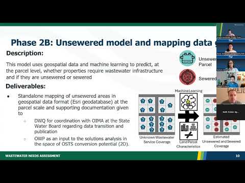
Project staff said the workstream will rely on three technical components presented to the advisory group: a parcel-level unsewered model from the University of Massachusetts Amherst, a spatial inventory of permitted treatment and collection systems, and an inadequacy-and-risk scoring framework that will produce lists of systems and facilities classified as "inadequate" or "at risk." Ariana Hernandez, project manager at the UCLA Luskin Center for Innovation, told members that Phase 1 of the needs assessment is in internal review and is expected to be posted publicly "on or around October 31." She said Phase 2 will assign solutions and cost estimates and develop a roadmap extending beyond the 2027 contract period.
Why this matters: The assessment seeks to give state policymakers a consistent, statewide basis to identify wastewater systems requiring technical, administrative or financial interventions. The lists and cost estimates are intended to inform funding priorities, the project team said, though staff emphasized the limits of the current scope and data availability.
Key technical work, timelines and deliverables - Unsewered mapping: Nelson DeLuis of UMass described a geospatial machine-learning model that will predict, at parcel scale, whether properties are sewered or unsewered. Deliverables will include parcel-scale maps and geospatial data to be shared with the Division of Water Quality and the Office of Water Programs.
- Spatial inventory of facilities: A separate effort will compile spatial boundaries or best-available…
Already have an account? Log in
Subscribe to keep reading
Unlock the rest of this article — and every article on Citizen Portal.
- Unlimited articles
- AI-powered breakdowns of topics, speakers, decisions, and budgets
- Instant alerts when your location has a new meeting
- Follow topics and more locations
- 1,000 AI Insights / month, plus AI Chat