Get Full Government Meeting Transcripts, Videos, & Alerts Forever!
Get email alerts on the Managed Aquifer Recharge topic
No spam. Unsubscribe anytime.
Cochise County uses high‑resolution Flow2D modeling to target Wilcox Basin recharge sites
Summary
County staff and consultants presented a week‑long, high‑resolution Flow2D hydrology and hydraulics model of the 1,700‑square‑mile Wilcox Basin and a GIS screening that identified 18 high‑priority sections for managed aquifer recharge; staff said the work will guide site‑level investigations and project design.
Cochise County Flood Control District staff and their consultants presented results of a Flow2D hydrology and hydraulics modeling effort and a GIS suitability screening that together aim to identify locations in the Wilcox Basin suited for managed aquifer recharge and flood mitigation.
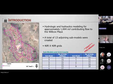
The work session on Tuesday, Sept. 30, included a technical briefing from Sai Miller, an engineer with J.E. Fuller Hydrology & Geomorphology, and a follow‑up screening study from Lindsey Bunting of Geosystems Analysis (GSA). Miller said the study area covers about 1,700 square miles that drain to the Wilcox playa and that the modeling effort divided that area into 13 linked models run on 40‑by‑40‑foot grid cells. "Flow2d essentially breaks up the terrain into a gridded mesh of square cells," Miller said, describing how the model routes runoff across cells and captures depths and velocities across the basin.
Miller said the team simulated a standard 100‑year, 24‑hour design storm using a type‑2 temporal distribution and ran verification tests against U.S. Geological Survey regression estimates. The modeling produces depth maps and hydrographs across the grid; Miller noted peak discharges in some cross sections approached tens of thousands of cubic feet per second in the larger drainages (the presentation cited a bottom‑left cross section with a peak near 27,000 cfs). He also said computation time for the full cascade of models was roughly a week on current hardware.
GSA's screening layered the Flow2D outputs with near‑surface and subsurface datasets — NRCS soil permeability for the top six feet, ADWR groundwater model drawdown contours, land use, and other variables — and scored 160‑acre parcels using a weighted ranking system to identify where captured runoff is likely to infiltrate to the aquifer. "Our goal at GSA specifically was to identify areas suitable for recharge," Lindsey Bunting said. The screening yielded a set of highly ranked parcels concentrated along major alluvial drainages such as Turkey Creek and Ash Creek; Bunting reported 18 full sections received the maximum suitability score in the screening.
County staff framed the modeling and screening as a pre‑feasibility step. Watkins, a Flood Control District staff member leading the county's program updates, told the board the modeling is intended to "analyze locations that will dual purpose recharge and flood control in the Wilcox Basin" and said the county will use the results to prioritize on‑the‑ground projects and to refine permitting and engineering work.
Consultants and staff said next steps include stakeholder outreach and targeted site investigations for a subset of candidate sites. Bunting said the project team will pursue a second, more detailed phase for up to five to eight sites that clears remaining data gaps — notably vadose‑zone and deeper subsurface data — and will use field methods such as geophysics, test pits and boreholes to confirm infiltration capacity before engineering design. She also said the screening intentionally ranked parcels that show continuous, high‑depth flow in Flow2D (for example, areas where more than 10% of a parcel holds more than 1.5 feet of depth in the 100‑year event) to avoid false positives from isolated depressions.
Board members raised jurisdictional and legal questions about basins that cross county lines; Supervisor Crosby (District 1) asked whether collecting water for recharge could trigger inter‑basin adjudication issues. Miller replied, "This watershed...does not go into the Gila River," noting the Wilcox and Sulphur Springs basins are closed to the Gila system. Staff also noted that groundwater basin boundaries (as mapped by the Arizona Department of Water Resources) do not always match surface divides, and that ADWR datasets will be part of the more detailed work.
Watkins and consultants emphasized limitations and the need for field confirmation. Bunting said some data are not yet available uniformly across the basin (notably vadose‑zone logs) and that field reconnaissance is required to rule out fatal flaws. County staff said identified candidate parcels and landowner interest will determine how many sites move forward.
The county said the modeling and screening may also be useful to county engineers in making permit and design determinations, and noted the outputs could inform refinements to Special Flood Hazard Areas where Flow2D depth mapping and FEMA flood zone maps diverge. The consultants and staff described the work as a planning and prioritization step; no formal action or vote was taken during the work session.
Looking ahead, staff said they will pursue stakeholder engagement (landowners and Natural Resource Conservation Districts), refine candidate sites for detailed investigation, and seek funding and partnerships to carry sites through design and construction.