Citizen Portal
Sign In

Council, planners spar over investing in Hilo and Kona amid tsunami, lava and wildfire risk

5823101 · September 23, 2025

Loading...

AI-Generated Content: All content on this page was generated by AI to highlight key points from the meeting. For complete details and context, we recommend watching the full video. so we can fix them.

Summary

Councilmembers pressed planners on an apparent tension in the draft general plan between encouraging investment in urban centers and discouraging infrastructure investment in high‑risk hazard areas. Planners said the plan includes hazard mitigation policies and implementation tools but requires community dialogue and follow‑on work (zoning, CDPs,

HILO/KONA — A sustained exchange at Hawaii County’s Sept. 23 special committee hearing focused on the tradeoffs between directing investment to established urban centers and avoiding infrastructure expansion in areas at high natural‑hazard risk.

Councilmember Kaguya raised a central question about downtown Hilo and Kona: how can the county support commercial and downtown areas while discouraging public investment that would increase density in high‑risk tsunami and flood zones? “They seem incompatible to me,” Kaguya said during the land‑use discussion.

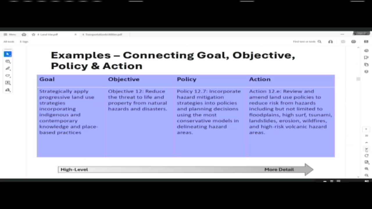
Planners pointed to explicit language in the draft general plan addressing hazards and mitigation. Bethany Morrison said Objective 12 seeks to “reduce the threat to life and property from natural hazards and disasters” and cited Policy 12.7 to incorporate hazard mitigation strategies using conservative hazard models; Action 12e calls for reviewing and amending land‑use policies to reduce risk from floods, tsunami, landslides, erosion, wildfires and high‑risk volcanic hazard areas.

Morrison and Director Jeff Darrow told council members that each type of hazard requires different approaches: elevation and engineering can reduce flood risk, but lava inundation presents limits on mitigation. “Each hazard has a potential for mitigation strategies or…accommodation, retreat or adaptation,” Morrison said.

Councilmember Ashley Kirkowitz, chair and presiding officer of the special committee, pushed back against approaches that would abandon communities. “I will not forsake communities. I will not say we will not invest in certain areas because of these certain things,” Kirkowitz said, adding that communities deserve investment and that the choices are not “black and white.”

Planners said the draft plan attempts to balance these competing demands by: (1) mapping urban growth areas and centers where infrastructure should be focused; (2) encouraging mitigation and adaptive design (elevation, building standards, relocation where appropriate); and (3) identifying tools — such as transfer of development rights (TDR) — to incentivize density where acceptable.

Hazard mapping and data Councilmembers asked how hazard data were applied. Morrison said planners used Civil Defense agency hazard models (updated periodically), Hawaii Volcano Observatory lava‑flow data, land cover and community wildfire risk ratings among other layers. She noted the wildfire community‑risk map exists but was not used as a primary input for the land‑use map; the county can overlay additional hazard layers and provide them to council members for review.

Darrow and planning staff acknowledged unresolved policy choices: whether to prioritize rehabilitation of existing urban cores in hazard areas, encourage retreat, or provide incentives to shift growth to lower‑risk centers. Several councilmembers said the absence of fixed short‑term answers threatens action and can cause stagnation in downtown areas.

Next steps Staff recommended continued public outreach, targeted community development planning (for example, a South Hilo CDP), code updates, and cross‑departmental implementation (public works, water, civil defense) to turn general‑plan guidance into executable projects. Planners committed to producing hazard maps and additional data layers for council review and to work with communities on acceptable levels of risk for different places.