Get Full Government Meeting Transcripts, Videos, & Alerts Forever!
Get email alerts on the Boat Launch topic
No spam. Unsubscribe anytime.
Redondo Beach shows three siting options for King Harbor public boat launch; Harbor Commission to weigh in Oct. 13
Summary
City staff presented three two-lane boat-launch options for King Harbor, described trade-offs in navigation, cost and environmental impacts, and said a state grant application requires a city resolution and a preferred location; Harbor Commission will consider a recommendation Oct. 13 and City Council is scheduled to act in November.
City of Redondo Beach staff on Wednesday presented three siting alternatives for a public two-lane boat launch at King Harbor and sought community feedback ahead of a Harbor Commission recommendation and a City Council resolution needed to apply for state grant funding.
The project team said the boat launch would be funded primarily through the California Division of Boating and Waterways grant program, but that the city must identify a preferred location and pass a council resolution before it can submit an application planned for February 2026. Greg Kapovich, waterfront and economic development director for the City of Redondo Beach, told the meeting: "I know we've been talking boat launch for years. Hopefully, this is the time we get it done." Harbor Commission consideration is scheduled for Oct. 13; staff said the commission will recommend a preferred alternative to City Council in November.
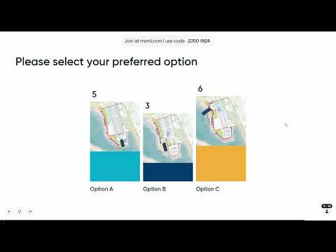
City staff and consultant teams emphasized that the choice of site will drive permitting complexity, cost and impacts. The City presented three alternatives (labeled A, B and C) all designed as two launch lanes with about 60 trailer parking stalls and 40–60 individual vehicle stalls. The key trade-offs described by consultants and staff were navigational width for commercial and recreational vessels, potential effects on shoreline and soft-bottom habitat, pedestrian and trailer traffic conflicts on the promenade, and cost and permitting difficulty with the California Coastal Commission.
Option A is the southernmost site, sited near the existing hoist and described by consultants as the smallest footprint and the most sheltered from wave action. Staff said Option A would likely be the lowest-cost alternative and would require limited dredging, with most construction on the land side. The project team said Option A meets the minimum design criteria and estimated a navigational width of about 130 feet; the consultant noted that the bottom-of-ramp elevation would be approximately -7 feet (mean lower water) and the top-of-ramp about +12 feet. The team also said Option A would require demolition and replacement of some Basin 3 shore facilities (including restroom and FOSS-area structures) to accommodate the ramp and parking.
Option B moves the ramp north along the west edge of the mole. Presenters said it would provide more navigational width (the team estimated roughly 170 feet) and more room for trailer queuing than Option A. Staff later clarified that Option B would place the ramp footprint over an existing restaurant site and likely require removal of that restaurant; meeting remarks included inconsistent earlier comments about whether that building could remain, and staff later confirmed the ramp location would conflict with the restaurant site. The team said Option B would have fewer green-space opportunities along the promenade and more potential pedestrian–vehicle conflict at crosswalks.
Option C is the northernmost alternative, oriented toward the harbor and described as having the largest footprint, the greatest navigational clearance (extending toward the breakwater) and the highest estimated cost. Consultants said Option C would require a higher ramp profile (top-of-ramp elevations shown at about +18 feet in the concept) and a protective sheet-pile or rubble wall to limit wave overtopping; staff estimated the protective wall would rise in the range of roughly +15 feet above typical water levels in places. Because the ramp would extend farther into the water column, consultants warned Option C would likely have the largest impact on soft-bottom habitat and would face the most stringent mitigation requests from the California Coastal Commission, making permitting more complex.
Presenters described studies completed to date: a coastal conditions/wave-monitoring study, a demand evaluation that supported a two-lane ramp and roughly 60 trailer stalls, a parking and traffic analysis of nearby intersections, and a site assessment tied to the 2022 King Harbor Public Amenities Plan (which originally recommended the mole D area for a launch). The city team said the Division of Boating and Waterways (DBW) requires a site preference and a council-authored resolution to accept a grant application; staff stated that DBW requires a minimum water depth at the design low tide and indicated a 4-foot design-depth requirement was used to size ramp length.
Attendees raised safety concerns for paddlecraft, paddleboard and rental operations already operating in Basin 3; several residents said small craft and commercial vessels could conflict with trailer-backed launches in tighter channel geometries. One resident said, "Those guys don't have a clue what they're doing," describing concerns about paddlecraft in shared circulation areas. City staff responded that navigational channels could be demarcated with buoys, queuing docks could be extended to keep trailers out of the main channel, and some rental operators might be asked to relocate their launching area as part of future design refinements.
Other issues raised by the public included operational hours, enforcement of time limits for parked trailers, potential fees, and whether additional breakwater work by the U.S. Army Corps of Engineers would be feasible. Staff said operational hours and fee structures would be policy decisions for the city and noted state grant agreements include maximum allowable launch fees under DBW rules; staff did not provide a firm fee number at the meeting. The team also told the audience that changing the U.S. Army Corps-maintained breakwater would be a separate process that likely requires coordination and resources beyond the city’s immediate control.
Next steps: staff will compile the public input from this session and present it to the Harbor Commission on Oct. 13; Harbor Commission will make a recommendation to City Council, and council is expected to consider a resolution in November authorizing staff to apply for the Division of Boating and Waterways grant and to identify the preferred alternative. Staff said a grant application is due in early 2026 (presenters used both "January" and later specified "February 2026" during the meeting) and, if awarded, the project schedule could move design into fiscal year 2027 with construction starting in summer 2027 and aiming for substantial completion by summer 2028.
Speakers cited in this report were Redondo Beach waterfront and economic development director Greg Kapovich; City of Redondo Beach senior management analyst Dave Cherobi; Jerry Holcomb, engineer with Moffatt & Nichol; Han Fu of SWA; and multiple residents who spoke during the public-comment portion. Jerry Holcomb, describing his involvement as an engineer and as a local boater, said: "I'm a local boater, so I'm really excited to get this done. I want to use this boat launch ramp myself."