Residents press safety and flood-zone concerns as planning commission approves tentative parcel map in 3 Rivers
Get AI-powered insights, summaries, and transcripts
Sign Up Free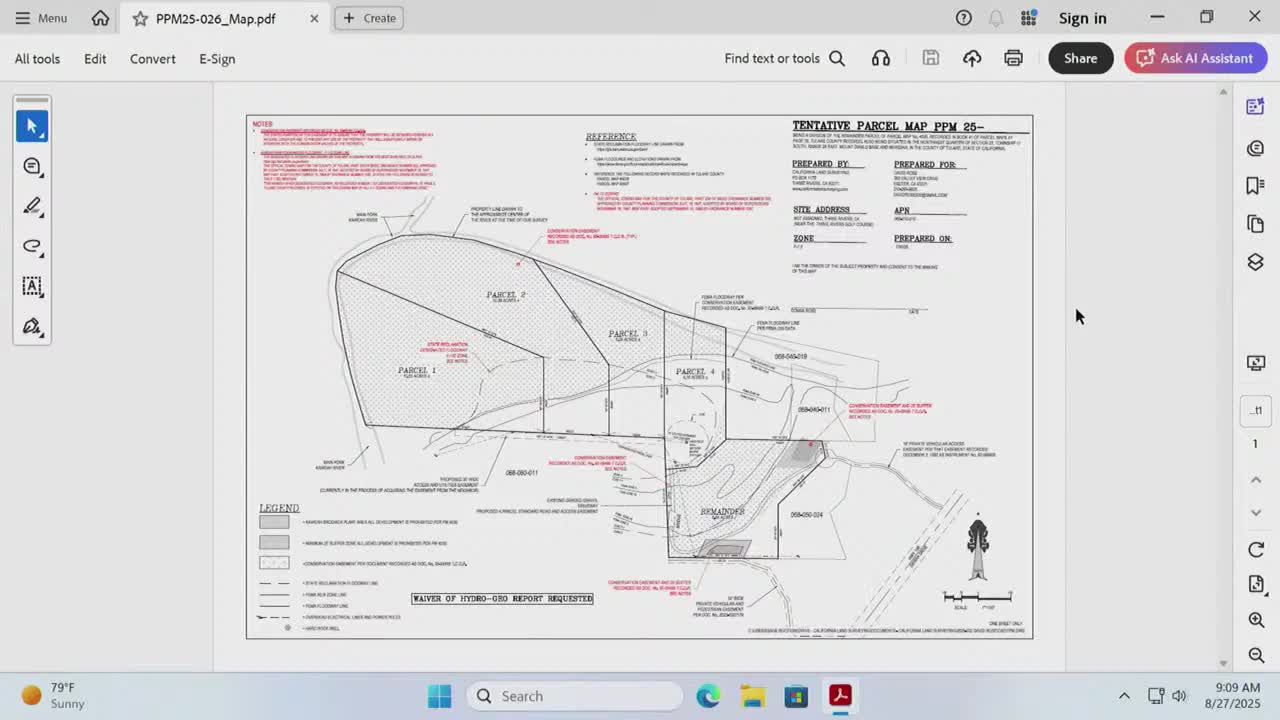
Summary
Neighbors told the commission they are worried about a private access road’s condition and floodplain buildability after the commission conditionally approved tentative parcel map PPM25-026; staff reiterated conditions addressing floodplain, conservation easements and access easement acquisition.
Neighbors and the project agent discussed access, floodplain and habitat constraints during the hearing on tentative parcel map PPM25-026 in the 3 Rivers area, but the planning commission voted to conditionally approve the tentative map with conditions addressing floodplain, conservation easements, biological resources and vehicular access.
Tammy Rivas Souza, who said she lives at 41233 Sierra Drive in 3 Rivers, told the commission she was representing family members who adjoin the project site and said her primary concern was the private road entrance off Highway 198. "The gate is 12 feet. Literally, the road is falling in and about to fall in on our pad right at our house because it has not been maintained," Tammy said, adding residents worry about speed, dust and safety on what she said is effectively a 12-foot gate and narrower driveway.
Staff and the agent explained the tentative map is subject to engineering, road and fire standards before final map approval. Staff member David Alexander read conditions of approval on the record that the commission included in its conditional approval: no residence shall be built within the F1 primary floodplain zone (condition 6); no residence shall be built within an identified conservation easement (condition 7, as recorded in the referenced exhibit and resolution); no construction activity may encroach into an area identified by the California Natural Diversity Database as potential habitat for listed plants (condition 8); and proposed parcels will be accessed via a private vehicular access easement (PVAE) across APN 068-060-011 and the county is processing acquisition of that PVAE — if acquisition fails, an alternative PVAE will be designed on the final parcel map (condition 9).
Sage Root, who said they represented "California Land Surangue" and drew the tentative map, told the commission the easement in question was created in 1992 and that current assessor maps show a 60-foot private road in that location; Root said the easement rights permit improving the access to an 18-foot width, though the surface currently is narrower and includes steep cut and fill slopes in places. Root noted that, if the PVAE cannot be secured, an alternative alignment would be considered for the final map.
Tammy pressed whether road improvements would be required before the split or before any homes are occupied; staff replied that the parcel map is tentative and that road improvements to county and fire standards (and bonding if necessary) must be provided before final occupancy: "By the time any homes are occupied, they'll have to have the road," staff said.
After public comment and staff explanation of the conditions, Commissioner Bill Whitlatch moved for approval of the appropriate CEQA exemption and approval of the tentative parcel map with final-map requirements; the motion passed on a 6–1 vote with one commissioner absent.
The record notes the PVAE is "in the process of being acquired" and that if it cannot be secured a different access will be designed on the final parcel map. Staff advised that residents may raise code compliance or engineering issues directly with the Resource Management Agency if conditions are not met.
The approval requires a final map showing road and engineering improvements, and the county will monitor the PVAE acquisition and any required design alternative prior to final map recording.