Get Full Government Meeting Transcripts, Videos, & Alerts Forever!
Get email alerts on the Comprehensive Plan Amendment topic
No spam. Unsubscribe anytime.
Commission backs future land-use change on northeast US 380 corridor to accommodate industrial and mixed-use development
Summary
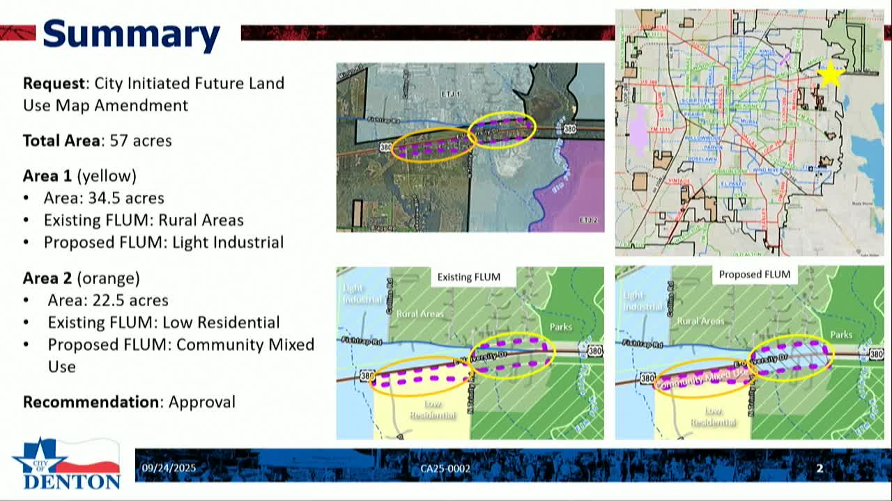
The planning commission unanimously recommended amending the comprehensive plan to re-designate about 57 acres along US 380: roughly 34.5 acres from rural to light industrial and about 22.5 acres from low residential to community mixed use, citing development inquiries and planned TxDOT roadway changes.
The Denton Planning and Zoning Commission on Sept. 24 voted unanimously to recommend a City Council amendment to the Future Land Use Map for two areas along the far northeast US 380 corridor.
Area 1 (about 34.5 acres) will be recommended to change from Rural Areas to Light Industrial, and Area 2 (about 22.5 acres) from Low Residential to Community Mixed Use. Staff said the recommendation responds to multiple recent development inquiries and to anticipated TxDOT roadway changes that will convert US 380 to a freeway with service roads in the long term.
Assistant planner Erin Stanley presented the corridor study that informed the request, describing current conditions as a mix of single-family homes, vacant lots, agricultural uses and driveways with some commercial and industrial uses in the extraterritorial jurisdiction. Stanley said traffic and infrastructure plans for US 380 and the city's growth goals make the corridor a logical place for light industrial uses closer to the roadway and for neighborhood-scale commercial and mixed uses that would buffer industrial activity from existing adjacent homes.
Stanley said staff held four community meetings (two in-person, two virtual) and mailed notices to owners within the area and to properties within 200 feet (and utility customers to 500 feet). She said the in-person meeting attendees who appeared were supportive and that the city received two written responses to the notice (one in favor, one opposed).
The recommended designations align with the comprehensive plan objectives to grow compactly, coordinate with transportation infrastructure, and match the existing nonresidential development pattern further west along US 380. Light Industrial is intended for light manufacturing, assembling and warehousing where adequate infrastructure and freight access exist; Community Mixed Use is intended to provide neighborhood-scale commercial services that complement nearby residential areas.
Commission discussion included questions about environmentally sensitive areas (ESA) near the Elm Fork of the Trinity River at the far east edge of the study area. Stanley said any development proposal that impacts ESA would trigger the standard ESA field assessment and mitigation or alternative ESA review; much of the ESA is on the outskirts of the proposed amendment area.
Commissioners asked about traffic. Stanley said future development proposals would be subject to traffic studies and TxDOT coordination; she said that in some existing conditions homeowners currently have direct driveways onto US 380 and that heavier commercial development is more likely to include consolidated access, turn lanes and other traffic controls.
Commissioner Garland moved to recommend the comprehensive-plan amendment; Commissioner Catcher Sid seconded. The motion passed unanimously. The amendment will go to City Council for final action at its Oct. 14 meeting.